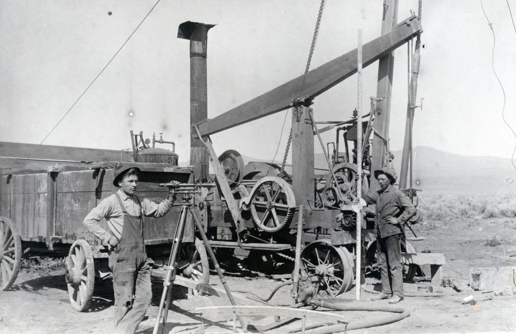
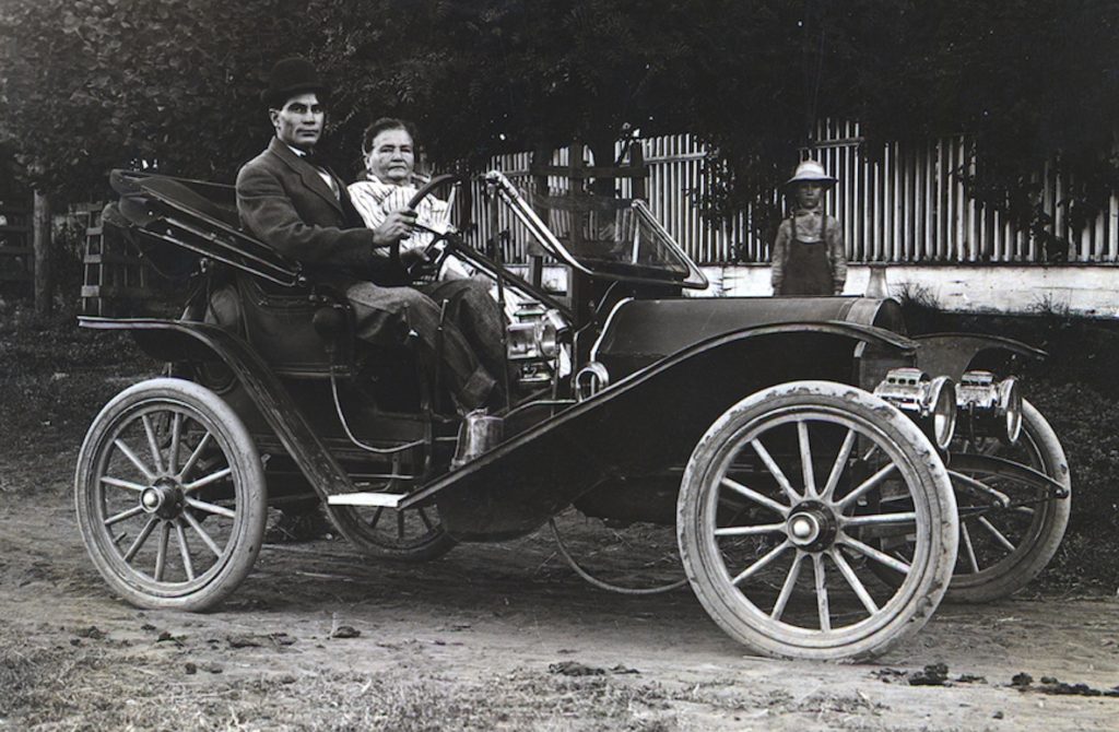
Caudle Brothers well drilling outfit, eastern Honey Lake Valley, 1910.
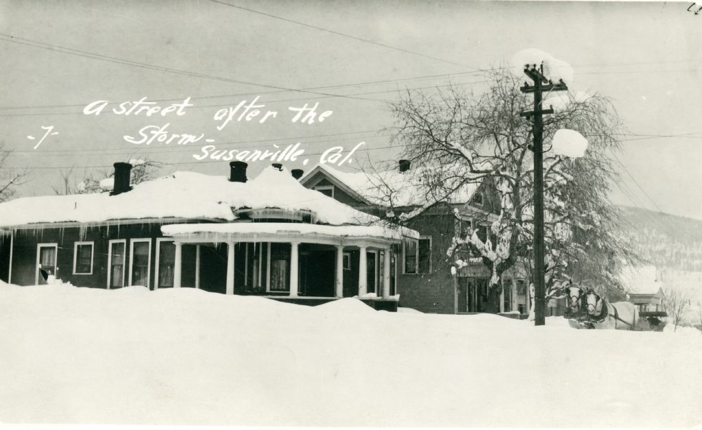
Note: Stacy was a small community in eastern Honey Lake Valley located between Amedee and the Nevada State line. In 1914, a weekly correspondent to the Lassen Advocate provided that newspaper of the activities of that region. From time to time on Tuesdays I will provide excerpts.
30 January 1914 – E.J. Howard finally got his steam traction drilling rig moved to the railroad near J.R. Burgess’ place and is now putting down a well for the S.P. Company at the signal tower where the Fernleyy & Lassen crosses the Western Pacific at Flanigan.
30 January 1914 – D.H. Gavin has been drilling a well for a desert entryman, but at 300 feet had not struck the water bearing strata.
30 January 1914 – C.W. Dickey has ordered from C.R. Caudle a propeller pump that can be inserted in drilled wells, seven inches drain and larger, to a depth of 140 feet, and a thorough test made of all stratas of water in the well to that depth. or what will rise from lower stratas up to that point or higher. It is not thought practical to pump from greater depths if it can be avoided. But the time is coming when pumping from 300 and 500 feet depths will be practicable and profitable.
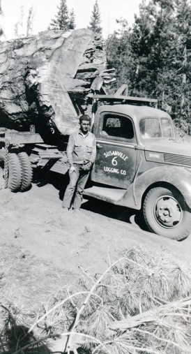
Joe “Tunney” Zunino posing with his one log load- Margaret Purdy
Several people contacted me in November about the above photograph. I had an initially published on March 28, 2019. Lo and behold it was recently posted on social media. It should be noted, that I do not have a Facebook account, etc. There are a lot people who help themselves somewhat generously I might add, and repost them either in newsletters, social media and who knows wherever else.
In this instance, I was a little peeved. The person who did the “lifting” of said picture and reposted it, identified the man in the picture as my father! Far from it. My Dad was connected with the Susanville Logging Company. Before Susanville, it was Purdy Bros LoggingIn 1958, Susanville Logging re-organized and the new owners consisted of Dale Soule, Paul Langslet, James Purdy and Leroy Purdy. The company operated a sawmill on Johnstonville Road and in 1993 when Jeld-Wen Corporation owned it, it was closed down. End of story.
The imported buffalo and elk at Wingfield Ranch, south of Susanville, 1920. Courtesy of Lola L. Tanner
There is evidence that the Great Plains Buffalo aka Bison territory was far reaching into the regions west of the RockyMountains, including the Great Basin. Dr. C. Hart Merriam, (1855-1942) was a multi-faceted individual who adorned many hats from zoologist ethnographer. In his studies of a naturalist in the West he intrigued about mammals historic territory. Unlike his colleagues, he contacted Native American tribes for their knowledge. Merriam soon realized this resource was finite. He focused on many Native American tribes elders of Northern California. Because of his work, we have a window of the past.
Merriam recounts that the Indians of the Northeastern
California, which he deemed trustworthy and that indeed buffalo did roam there. In Lassen, particular, the buffalo they inhabitated the eastern side county primarily, Madeline Plains, Horse Lake and Pine Creek Valley. It is belief that the buffalo in these parts had disappeared prior 1800. It should noted that in 1930, when a reservoir went dry in southeastern Oregon they discovered skeleton remains of a bison.
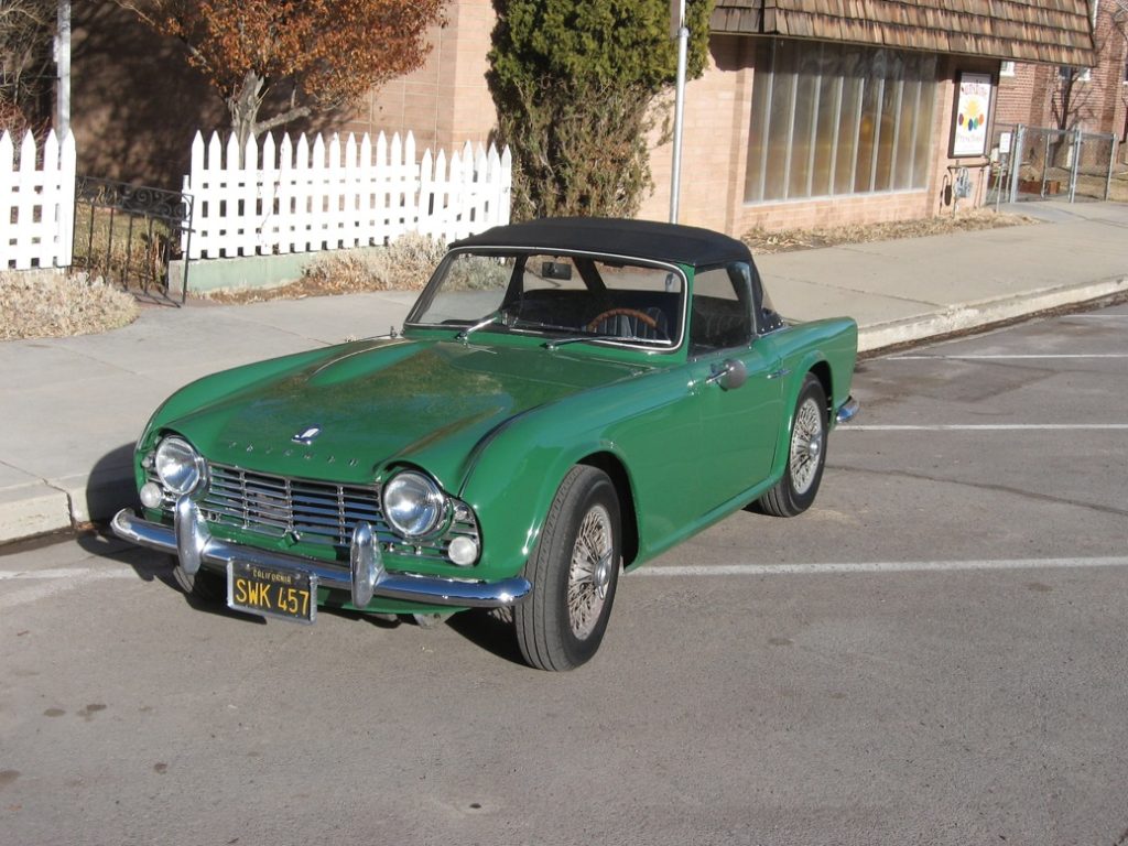
The 1964 TR4 Triumph at Tanner Ranch, Honey Lake Valley Valley, 2004.
It was on December 14, 1964 when this 1964 Triumph TR4 rolled off the assembly line in Coventry, England. It would eventually be shipped to a car dealer in San Francisco. It remain unsold until 1966, when it was sold to Susanville resident Frank White.
The Triumph TR4 with its winter top.
When Frank allowed me to drive it for the first time, I became enamored with that little hunk of metal. While I waited very patiently for Frank to sell it to me, he did graciously allow me to drive it around from time to time. Here is a little fun fact that some might not be aware, but the Triumph is the only car I have ever owned!
Those rail fans may find this appealing, while others not. On the other hand it is documented for posterity.
Lassen County had to go through unusual hoops with railroad crossings at Wendel. They had to contend with the NCO’s narrow gauge and Southern Pacific’s standard gauge. In 1924, the county wanted to make a road alignment. The Southern Pacific agreed and provided the map above.
Personally, I have special affinity for architecture, but my honest opinion I disagree with this newspaper article as follows.
In July 1908, it was announced that Susanville pioneer merchant David Knoch hired Enhorning & Harrison to construct a house at 100 North Roop Street. The Lassen Advocate noted: “The Knoch residence on the corner of Roop and Nevada streets is a one-story edifice, 32×62 feet and will contain five rooms, bath, closet and pantry. It will be bungalow style, with a round tower on the corner. The building be wired. throughout, and strictly up-to-date in all its furnishings and appliances.”
100 North Roop Street, January 1916.
First and foremost, bungalow style homes do not have a semi-circular porch. Second, I knew owners Lyle “Dan” & Nadene Wemple and frequently visited them during the late 1970s. The interior of the house basically remained the same as it was built–bland. There were was no wood work features and/or cabinetry associated with a bungalow.
On a side note Enhorning & Harrison kept busy, besides Knoch residence, they built the Borrette next door in that same year. In 1909 they constructed houses of 120 and 130 North Roop Street.
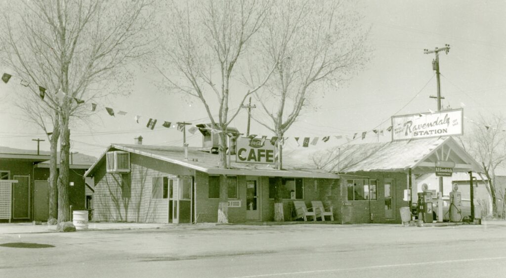
Back in July I did a request post for information about the Ravendale Bar and Restaurant. Armour Edwards built a service station in 1925. Some time after the repeal of Prohibition in 1933, a bar and restaurant was added. Over the years a motel was constructed across the highway.
The Ravendale Garage., circa 1930
This enterprise was a favorite with locals and travelers alike. It 1955 it was named Ravendale Station. The business was a limited partnership between Leo and Martha Burdick and Paul Langslet.
The landmark bar/restaurant burned down in the fall of 1983, either in October or November. The fire was of suspicious origin and one person recalled that when the fire was discovered it was burning at two separate locations. When more information about the history of the establishment becomes available an update will appear.
Stacy was a small community in eastern Honey Lake Valley located between Amedee and the Nevada State line. In 1914, a weekly correspondent to the Lassen Advocate provided that newspaper of the activities of that region. From time to time on Tuesdays I will provide excerpts.
30 January 1914 – Ferdinand Zarbock, who has been keeping the Postoffice at Stacy the past month, is very. much gratified over the results since the office has been regular service over the Fernley & Lassen Railroad. The sales and cancellations have more quadrupled from what they we were getting intermittent service from Calneva.
30 January 1914 – Marvin Caudle and Ferdinand Zarbock have just completed the survey of Main Street from the northern limits of Stacy for a distance of one mile north and have moved and rebuilt the old fence so as to give a 60-foot road. They are now working on the trunk line of the Stacy telephone system.
Tim
P.S. Seeking a special holiday surprise, you can always give a gift Subscription
Chester, California, 1914. Courtesy of Dolores Gasperoni
On April 26, 1894, the Chester Post Office was established at Burwell Johnson’s establishment, which included a saloon plus rooms for travelers. Johnson’s was located at the base known today as Johnson Grade on Highway 36, approximately where the causeway begins. The post office was named after Chester, Vermont, former home of the Jonathan Martin family, Johnson’s neighbors, who were instrumental in the development of Chester.
In the early 1900s, the Great Western Power Company began acquisition of properties of Big Meadows, which it was their intent to construct a reservoir for hydro-power development. This they did, and the reservoir is known today as Lake Almanor. The Martins along with their neighbors Olsen sold their properties to Great Western Power, retaining everything about 4500 elevation contour. In 1911, Edith Martin hired Everett M. Cameron to survey and subdivide her property and thus, the town of Chester was born.
Bill & Franceska Neuhaus, Willow Creek Valley, with Leo Murrer in the background, circa 1912–Phyllis Beard
Several people asked for more information on my great great grandmother Franceska, since they were intrigued at the age 74 she went in hotel business when she had a St. Francis Hotelconstructed in 1914.
For starters she was born in 1840 in Switzerland. In 1858, she married fellow countryman, Jacob Murrer. She gave birth daughter, Pauline, in 1859. The following year, Jacob and Franceska migrated to California, leaving infant Pauline care to her parents. The Swiss couple moved around a lot in Northern California where Jacob tried his hand mining, but fell back as a dairy farmer. Their family grew by additional five children–Jacob, Edward*, Mary, Emma and Rose. In 1874, the family moved to Willow Creek Valley, north of Susanville. On July 4, 1876, Jacob died of a heart attack, leaving Franceska to a daunting task of trying to make a living on the 160-acre homestead. After all, Franceska now widowed at the age of 36, had the responsibility of raising her five children who ranged in the age from 3 to 14 years.
This is where the story gets interesting and revealed her strong character. Franceska did find solace with her neighbor Ben Neuhaus. Since they both spoke German.. She had someone she could easily converse with, as she had trouble speaking English. There was an added bonus that they were both devout Catholic. On April 20, 1879, Ben and Franceska were married at Reno, Nevada. It was an unusual union for that they both kept separate business accounts. In early 1900s, Eulalee (Yoakum) Trussell, who grew up on the San Francisco Ranch (now Five Dot), explained this arrangement. Eulalee recalled when Franceska told her about her marriage to Ben, “That we did not marry for love, but marry the ranches.”
50 North Gay Street as it appeared in 1919. This was the home of Ben and Franceska. Courtesy of Leona F. Byar, a grand daughter of Franceska.
In 1902, Ben and Franceska retired from ranch life in Willow Creek Valley and moved to Susanville. They leased a ranch for $1,000 a year. Franceska invested in Susanville’s commercial property and did quite well. In 1912, they sold the Willow CreekValley ranch to Edward Murrer for $13,000. Edward made a down payment of $1,000 and paid balance the following year. Flush with cash, Franceska’s final venture was for the construction of Susanville’s St. Francis Hotel, that son and daughter-in-law Bill and Flora Neuhaus would operate. It should be noted that Franceska was well versed in the inn keeping business. For years the Neuhaus home in Willow Creek was well known for its hospitality to accommodate travelers. Her daughter, Rose, operated hotels at Hayden Hill and Susanville. Rose’s home in Susanville happened to conveniently located behind the St. Francis Hotel and her elaborate flower garden complimented the hotel.
815 Cottage Street, Susanville, February 3, 2018 This was home of Rose Murrer Bagin.