Lassen County – Devil’s Corral

Devil's Corral Bridge, 1918. Courtesy of Margaret A. Purdy
Devil’s Corral Bridge, 1918. Courtesy of Margaret A. Purdy

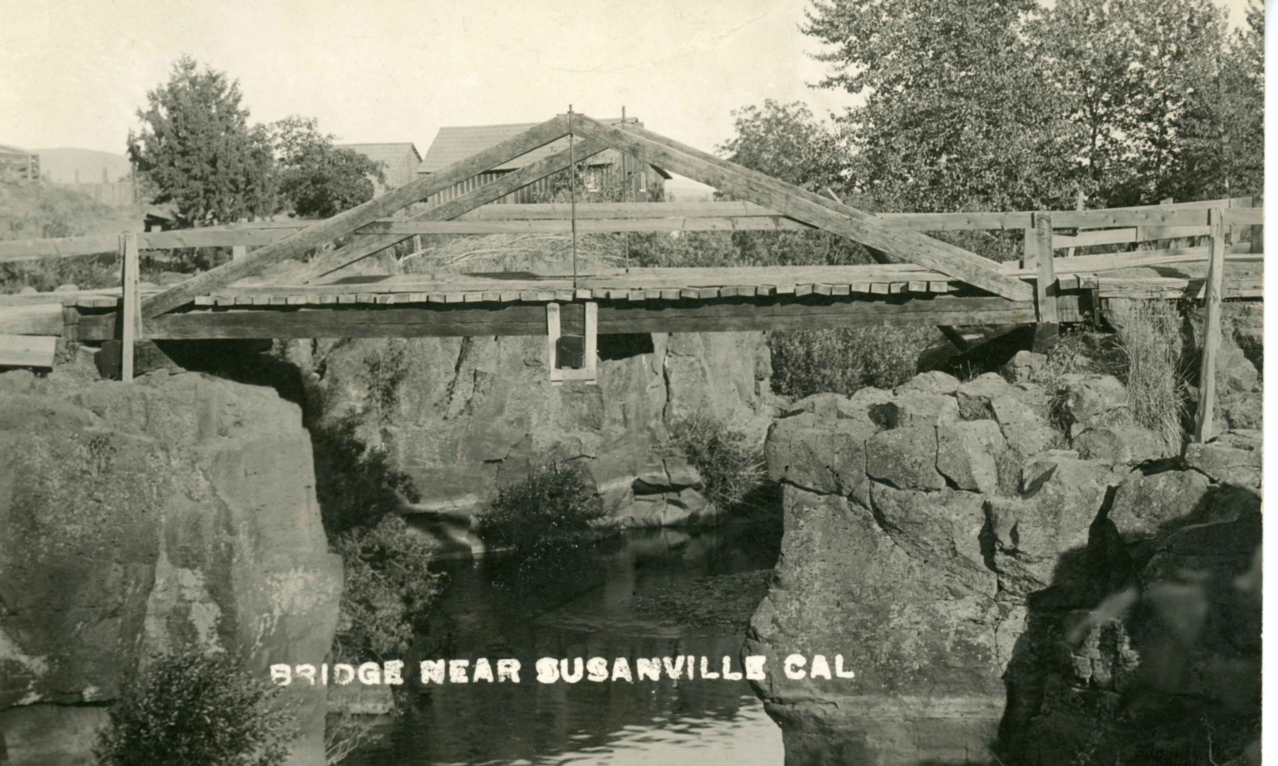
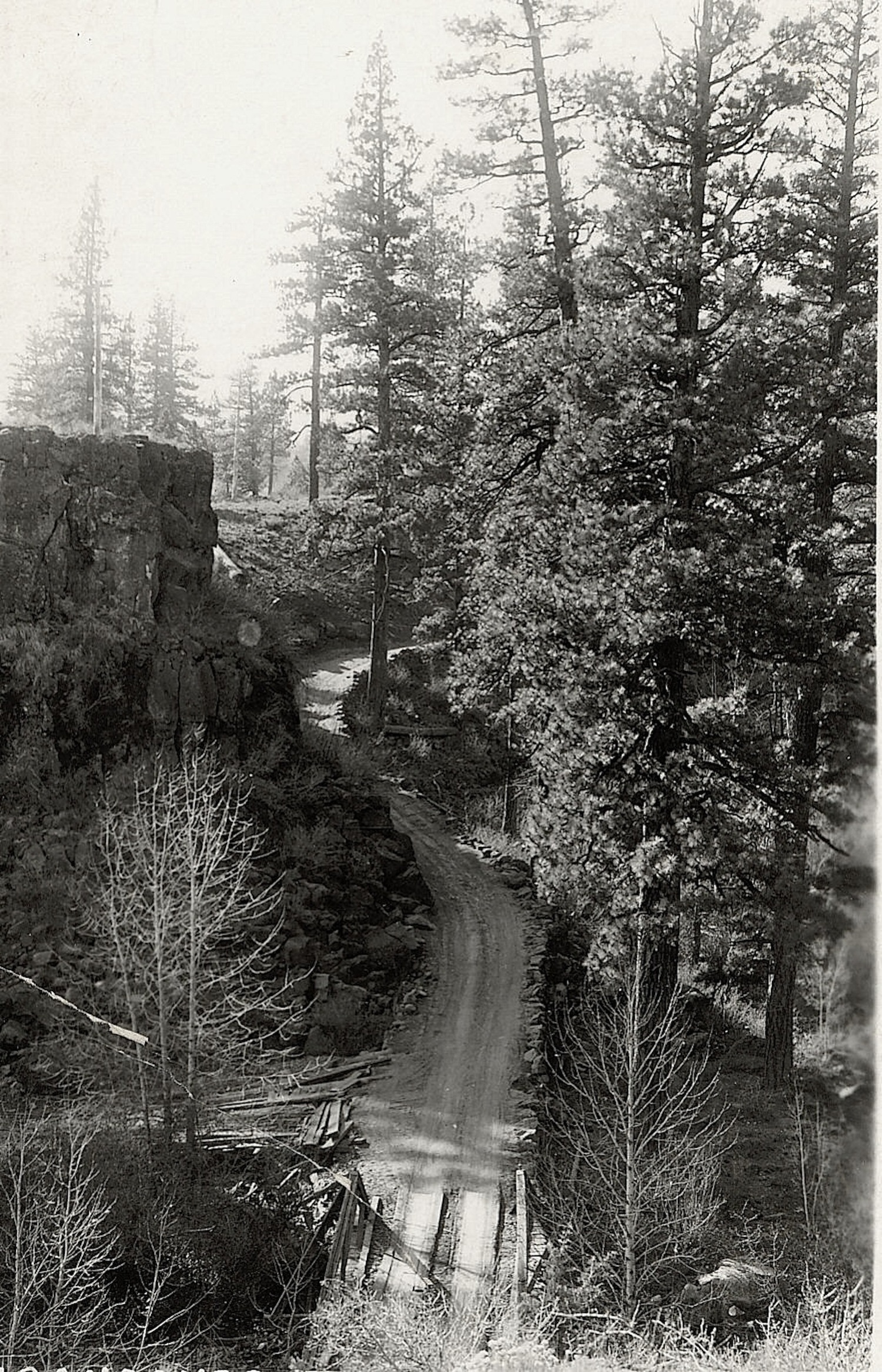
The circumstances leading to its name are not known. There are two possible explanations. In 1865, San Francisco journalist Lisle Lester wrote: “Late in the afternoon we crossed a weird looking place of a rock wall enclosing a little flat meadow land called Devil’s Corral. The place is historical, for in the early days a band of emigrants stopped here to feed their stock and were overtaken by disease which covered the little nook with the bones of their cattle, and added to its soil many a way-worn form. For years the bones of the cattle bleached here in rude piles.”

In 1923, when the first highway bridge to span Devil’s Corral was completed, this published version made its debut: “The name was given the curious lava rock formation on the banks of the Susan River at this point by early day wagon trains who sought to reach the Sacramento Valley by following the course of the Susan River. At this point the perpendicular rock walls of the canyon made further progress impossible and they were forced to turn back, hence the name Devils Corral.”

It is never too late, subscribe today and enjoy tomorrow with daily notifications. You can also surprise someone with a gift subscription

Susanville – Richmond Road Bridge

Richmond Road Bridge, circa 1910. Courtesy of Lola L. Tanner

Yesterday, we examined the route out of Susanville’s western boundary. For some odd reason, I must have transportation issues on my mind.  To leave town to the south, required crossing the Susan River. Just like how Pine Street at one point became Prattville Road, the same name change occurs wherein South Weatherlow Street ends on the north side of Susan River and after one crosses the bridge, the route becomes Richmond Road.  The wooden bridge crossing the river was a contentious issue between Lassen County and the City of Susanville once the railroad was constructed. Back then, the river served as the southern boundary of Susanville. The wooden bridge could not support the heavy freight arriving at depot on Richmond Road.  It took some time for the two entities to agree to split the costs for a new bridge.

It is never too late, subscribe today and enjoy tomorrow with daily notifications.

Prattville Road

Susanville's North Pine Street, January 1916.
Susanville’s North Pine Street, January 1916.

Last month when I wrote about Plumas Pines, someone inquired about Prattville Road.  Prior to the construction of State Highway 36, west bound travelers from Susanville ventured up North Pine Street, which at that time ended at North Street. From that point onward it was designated as Prattville Road. The original town of Prattville was located at Big Meadows, Plumas County prior to the construction of Lake Almanor. At that time, Prattville was the next community west of Susanville, hence the name of Prattville Road. Continue reading Prattville Road

Building Westwood

One of the nice features using this forum, instead of traditional print, some photographs will not print well. The above is a perfect example, yet it is an interesting photograph. This is at 501 Main Street, now Uptown Cinemas. This caravan of equipment is headed to Westwood while the first sawmill was under construction. Courtesy of Marcella Mathews Searles.

When the Red River Lumber Company finally decided, or actually more to the point Fletcher Walker demanded the Mountain Meadows location or otherwise he was going to quit, there were numerous hurdles to overcome.

During the initial construction phase of 1912-13, everything would have to be freighted in, while the railroad was under construction, and it would not be completed to Westwood until February 1914.

Highway 36 Fredonyer
The road over Fredonyer as it appeared in 1914.

The bulk of the machinery was shipped by rail on the Western Pacific to Doyle. Smaller shipments also went by the Western Pacific to Keddie. In either instance, that is still a long haul for all the machinery to build one of the largest electric sawmills. In addition, all the auxiliary items needed to build a company town. This is before paved highways no less, and the truck traffic certainly made its imprint on the roads, though not in a favorable way.

Hopefully, bringing you this information, it might give you a tiny incentive to part with five dollars a month to keep things running.

Fernley & Lassen Railroad

This cut is just west of Susanville at Miller Road.

Since today is Lassen Land & Trails Trust annual Rails to Trails festival, it is only fitting to share a few scenes of the construction. In September 1913 work began on the construction of the line from Susanville to Devil’s Corral. This segment provided railroad officials with numerous challenges, since there were hardly any physical barriers to contend with the segment from Fernley, Nevada to Susanville. Time was also of the essence, since the railroad had a contractual obligation to complete the line to Westwood by February. With that in mind, over 1,000 men were hired for this construction phase.  On December 12, 1913, the construction train crossed the Devil’s Corral, and all appeared well, until Mother Nature unleashed a fury of storms, which is a topic for another time.

Construction train in the Susan River Canyon.

It is never too late, subscribe today and enjoy tomorrow with daily notifications. You can also surprise someone with a gift subscription.

Susan River, 1981

Susan River from the Carroll Street Bridge, 1981. Courtesy of Jim Cooper

While going through a photograph transfer file, in search of a particular photograph that I thought had been scanned, I came across this one of interest. By the way, for those inquiring minds, I never did find what I was looking for.

When I returned home a couple of weeks ago, I noticed the Susan River still had a pretty good flow, considering the circumstances of the drought. In the summer of 1981, gabions were installed along the south bank of Susan River just below the Carroll Street bridge to prevent further erosion of the bank. As one can easily see, there was not much water in the river to divert during the project.

It is never too late, subscribe today and enjoy tomorrow with daily notifications. You can also surprise someone with a gift subscription.

Eagle Lake’s Historic High Level

Notice how the water in this 1917 postcard is in the trees at the current marina site.
Notice how high the water is in the trees at the current marina site.

Note: While I am getting around better, I still have a long way to go. Some might have noticed that the published October Preview has deviated from what was intended. My apologies, but scanning images to accompany topics, has presented a challenge, due to my ongoing recovery from a broken hip. Please have patience sooner or later the intended topic will appear.

It is only fitting that a week ago, I attended the Eagle Lake Interagency Board meeting and yesterday’s Lassen County Planning Commission meeting. Since so much focus has been with drought levels of Eagle Lake, and groundwater basins, I thought let’s take a look at the other extreme. Continue reading Eagle Lake’s Historic High Level

Bert Rodman

Bert Rodman
Rodman’s grave was part of my Westwood Cemetery Tour

Rodman was part of the large influx in Westwood’s population during World War I. He came there from Akeley where he worked in bank, but there being no financial institution he went to work in the mill. That would change when Red River decided to go into the banking business in 1920 when it formed the Westwood National Bank. The bank was a very contentious issue among the Walker family, but it was one of many of the heated exchanges the family engaged in. Anyhow, the bank was conveniently located in the office building across the street from the Big Store and the mill entrance. In 1921, Rodman accepted the position of head cashier at the bank, a position he held until 1936, when Red River got out of the banking business when it sold it to the Bank of America. He died in 1943 and is buried in the Westwood Cemetery. On a final note, a remnant of the bank still remains, the concrete vault across the visitor’s center.

Subscribe and support this site for as little as $5.00 a month, or a mere 16 cents day.

Secret Valley Paiutes

Secret Valley, as seen from the lower end of Secret Valley.

The Paiutes of Honey Lake/Secret Valleys were known as the Wadatkut.

The Secret Valley band consisted of 20-30 people. Ike Northrup who passed away in 1953, is one of the best known members of this tribe.

In the summer they made their home at the north end of Secret Valley, near the old McKissick Ranch, near Karlo. In the winter, they would relocate in the Honey Lake Valley, east of Litchfield. By the late 1890s,  some members of tribe would find seasonal employment there on the nearby Gibson Ranch.

For more information see Francis Riddell’s  Honey Lake Valley, Paiute Ethnology,  Nevada State Museum, Occasional Papers No. 3, 1978 . Riddell grew up in the Honey Lake Valley during the 1930s, as his father was hired to work on plans for the troubled Bly Tunnel at Eagle Lake. While attending school at Missouri Bend, Francis found arrowheads in the school yard and that was the beginning of his career in archaeology.

Please subscribe and support this site in providing quality historical information of Northeastern California. A five dollar contribution goes a long way towards a worthy cause.

Susanville Coca Cola Plant

The Susanville Coca Cola Plant as it appeared in the 1950s, during the Lassen County Fair Parade. Courtesy of Margaret A. Purdy

One subscriber wanted to know the history behind this plant, which is also known as the Susanville Bottling Works. I must confess a lot of ignorance, as to specific dates, etc, so this will be updated when new material surfaces.

The original bottling works was established around 1914 by H.W. “Pop” Wharton. It was located at 906 South Alley between South Weatherlow and Union Streets. The building, painted a chocolate brown, is still there and converted into apartments.

In 1923, Howard L. McMurphy took over the complete operation. It was an interesting and lucrative time to be in soda business  with Prohibition. It saw not only the local production of Coca Cola, but a local line of the Mt. Lassen brand of sodas.

Sometime in the late 1920s or early ’30s a new plant was constructed at Main and S. Sacramento Streets. For many the star attraction was the large picture window on Main Street, where people on the street could watch the assembly line of the sodas being bottled.

In 1967, Phyllis McMurphy Beard dissolved the Susanville Coca Cola Plant and the local production of sodas ceased.

For five dollars a month by subscribing, you can receive a daily email on that day’s topic, and in doing so, help preserve a bit of history.


Exploring Lassen County's Past