Eagle Lake – Bly Tunnel Question

Blasting at the inlet of the Bly Tunnel, 1921. Courtesy of Lola L. Tanner

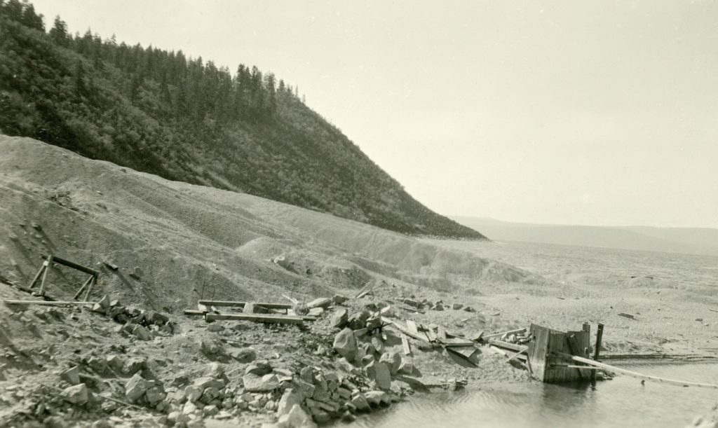
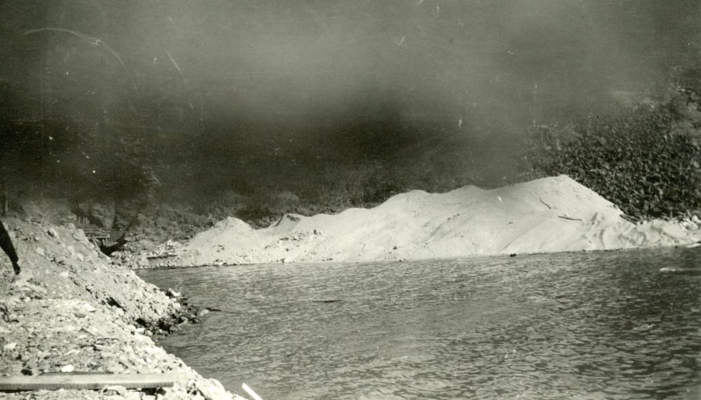
To the naked eye, today’s photographs does not look like much. For me I find it puzzling and I hoping someone can explain and/or give me some type of geology lesson.

The photographs were taken in 1921/22 at the inlet of the Bly Tunnel. The smoke depicted, in the above photograph, is from the blasting. What intrigues me is the tailing pile, which is composed of sand!  The tunnel was constructed through lava rock. So  where did the sand come from? By all means, please share this post to anyone who can enlighten me, and everyone else who would like further insight.

More sand. Courtesy of the D.M. Durst Collection

Subscribe.

Bagwell aka Fruit Growers Spring

The springs are located on the mountain side behind the ranch house compound. Courtesy of Hank Martinez

A subscriber wanted to know more about Fruit Growers Spring, also known as Bagwell Springs. These springs are located north of present day Susanville Ranch Park.

The springs were named for James Washington Bagwell, who located on 160-acres that included the springs. In 1893, he sold out to George W. Long for $300.  In 1901, William Black Long claimed rights to this spring that he designated as Bagwell. In 1919, the Fruit Growers Supply Company purchased the property for its water rights. For a number of years the spring was known as Fruit Growers Spring. It appears with that designation in the decree of Fleming v Bennett—the adjudication of the Susan River watershed. In 1935, Fruit Growers sold the spring to the Republic Electric Power Company, who purchased it as an additional water source for Susanville. Thereafter, the spring was once again referred to as Bagwell. The springs are now owned by the City of Susanville, which are used in conjunction with the city’s water system.

Subscribe!

Spoonville – Then and Now

Spoonville
Unfortunately, not the best photograph of Spoonville, back in its heyday. Courtesy of Spoonville native, M. E. “Mul” Mulroney.

This district some three miles or so east of Janesville was orginally known as Missouri Bend, due to the fact that a large percentage of the original settlers came from that state. The community has seen better days, and now falls under the proverbial category of a “wide spot in the middle of the road.” The town once boasted a two-story hotel, two stores, blacksmith shop, creamery and a school. The only original buildings is the residence of E.C. Brown and the Missouri Bend Schoolhouse.  For those who want to do a drive through, it is located today near the intersection of County Road A-3 and Cummings Road.

Spoonville, September 27, 2016

Subscribe!

Roxie Peconum

roxie-p
Roxie Peconum, 1954

The Peconom family is one of the better known Maidu families. If you noticed that I highlighted the name in bold, there is a reason. The family name has been misspelled for years with a um instead of the proper om. Of course, the name spelling was brought to light, during the proposed name change  of the first branch of Willard Creek to Roxie Peconum Creek to commemorate Roxie Yoanna Peconum (1851-1958), well-known member of the Maidu tribe, who gathered roots and berries in the region.  However, some thought the name should be for the Peconom family, and not an individual family member. If it was to be the latter, the name should be Yoanna Creek for Roxie. Whatever the case may be, on February 11, 1993  U.S. Board of Geographic Names approved the name change to Roxie Peconum Creek.

Subscribe!

Willard Hill

Willard Hill, 1940. Courtesy of Margaret A. Purdy

Willard Hill located some six miles west of Susanville was a popular winter sports venue. Its initial development came about through Lassen College’s Forestry Program inconjunction with the National Youth Administration. The latter provided each forestry student with not only academic training but to work in related forestry jobs. For their part-time work the students were paid $30 a month, however $20 a month was deducted for room and board in the converted Alpine Hotel dormitory. Continue reading Willard Hill

The Pioneer Brand Project

Brands
The interior wall at the Pioneer courtesy of Lassen Ale Works

With the Lassen Ale Works moving out of the Pioneer within a few months, has thrown a monkey wrench into this project. What the future holds for the Pioneer at this time, is not known. Should it close it affects the project, since the brands on the wall at that location and the story behind them go hand in hand. I will continue to gather the history of the brands, but the current circumstances places a barrier, and so whether a book will appear on the horizon, only time will tell.

Subscribe!

Fort Sage

Von Schmidt's 1872 Map.
Von Schmidt’s 1872 Map.

A military encampment located in the eastern portion of Honey Lake Valley on the Nevada side. “Fort” is a misnomer since it was actually a military camp and not a fort. Military records refer to it as Camp Sage, but provide no dates of operation or an exact location, only township and range. The camp served as a rest stop on the military supply route from Reno, Nevada to Fort Bidwell, California. In June 1872, Perry Jocelyn was in charge of Company D, Nevada Calvary, marched the troops on foot from Reno to Fort Bidwell—a distance of 250 miles. The route went north and east of Reno over the Fort Sage Mountains, to the west side of the Smoke Creek Desert and then criss-crossing the California-Nevada border until it reached Surprise Valley. It was a difficult journey. Jocelyn found that out first hand, on the first day of the seventeen-day march, five soldiers deserted in the middle of the night. An attempt was made to locate them, but they were never apprehended. Unfortunately, Jocelyn’s diary only contained the following notation about the place: “June 2, 1872 – Rev. at 3. First wagon mired within one hundred yards of camp. At 8 o’clock train has not advanced more than one half mile. Cross large hill where it is necessary to double the teams. Newcomb’s ranch just on the other side with lake nearby. Four miles further with still heavier hills, Fort Sage is reached. The whole distance eight miles.” Continue reading Fort Sage

The Chinese of Lassen County

The staff of the St. Francis Hotel, 1915. When it first opened its door for business in 1914 and for many years, they hired Chinese to manage the restaurant, though they advertised the menu as American cuisine. Courtesy of Leona F. Byars

Back in the mid-1970s, I was part of the Chinese American Survey Project. The goal at that time was perform a record search, public and private, concerning the Chinese in every county of California. Not only did I do the search for Lassen County, but that of Modoc, Plumas and Tehama Counties.

Of course, I learned a lot about the historic Chinese population of Lassen County.  Take for instance the earliest land record dated September 14, 1864 wherein Chew Henry sold a lot in Susanville to fellow countryman Hoa for $266. This particular lot, it should be noted is the current site of Susanville’s Elk Lodge. This same parcel was sold in November 1865 by Shong Lee to Isaac Roop for $150.

In the future, I will write more about the Chinese historical role in Lassen County history. Take for instance Susanville had two distinct “Chinatown’s.”

Subscribe!

Eagle Lake – Papoose Meadows

A 1923 view of Papoose Meadows. Courtesy of Lola Murrer Tanner

On September 21, 2016, I ventured to Papoose Meadows near Eagle Lake. It had been a long time since I had been there. This excursion was a bit different than most, and resulted in the proverbial “Pandora Box” of so many issues. So not only in the near future, there were will be a few posts about the history of Papoose Meadows, but an interesting perspective about Leon Bly, whose Eagle Lake’s irrigation project had a major impact on the region. Stay tuned, as there is some interesting new material to be revealed.

Subscribe!

Happy New Year!

The Honey Lake sail boat regatta, 1987.

Well, we certainly covered a wide variety of topics in 2016. This year we will continue to do the same. Recently, I unearthed new material relating to Leon Bly and his failed Eagle Lake project.   I also look forward to visiting some obscure historical sites to photograph and share them with everyone.  So sit back, and  relax in knowing there is plenty in store for 2017. Don’t forget you can always go back and examine prior posts, which there are some 700+.

I also hope, that some of the readers will step up to the plate to subscribe.  While there is a following of some 9,000 readers a month, less than 100 actually subscribe and/or donate. So, I hope a few will surprise me with a contribution, after there are various costs to maintain the site, such as host/server and domain fees.

Support by subscribing.

Exploring Lassen County's Past