Tag Archives: Native American

Mattie Jackson Ives

Mattie Jackson Ives

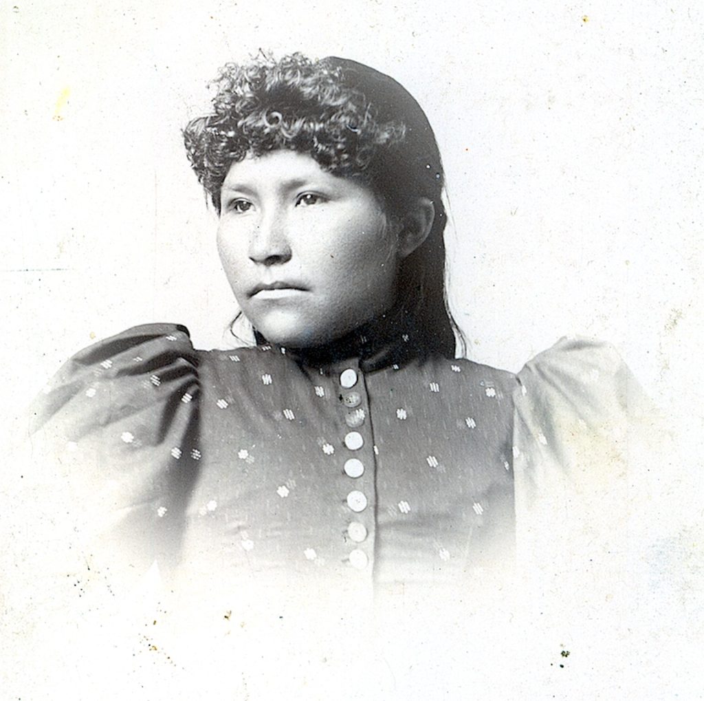
We do not know much about Mattie Jackson Ives. A Maidu, she was born circa 1878 in Susanville, the daughter of Sam Jackson and Chief Daughter. In 1900 she married Pete Ives and spent the majority of her life on the family ranch in Willow Creek Valley.  She died there on September 2, 1932 and is buried at the Indian Cemetery near the family home. What is remarkable and very rare is that she went to a professional photographer in the early 1890s  to have her picture taken.

Subscribe

Pit or Pitt?

Pit River, near Bieber, 1910.

In 1843, Pierson B. Redding gave the river and the Native American tribe located there, the name Pit. Reading noted there were numerous “pits” along the river, and some could be hazardous to your health.

Then there is the small community of Pittville that is on the Lassen and Shasta county line. As to the spelling with the double “t” the Shasta Courier noted in 1900 that the only folks who spell Pit with a double “t” are the ones who do not know the history of the naming.

Subscribe

The Summer Solstice Tour

Sunrise Chamber, 2015

Were you aware that the Belfast petroglyph site also serves as ancient observatory?  This event only occurs on the morning of the summer solstice when the sun enters a chamber highlighting a variety of glyphs, among other things. It is quite the sight to see.

sunrise chamber
The sunrise chamber.

This is an early morning excursion and I mean early as we gather at 5 a.m. to make the trek. In preparation attendees receive in advance John Rudolph’s paper, “An Ancient Solar Observatory.” If there is enough interest we can make the trip again this year. Please let me know. One final note the solstice occurs on Thursday, June 21.

On Wednesday, June 20, I will send an email with all the details.  However, if it is overcast there is no sense in going.

Note: There is a $5.00 fee for non-subscribers.

Never miss a story, click here to subscribe and support.

Importing Water From Where?

Butte Lake, circa 1920. Roy Sifford, of Drakesbad fame wrote: “The sign of the Manitou which means the sign of God. The shadows in the water made a long arrows which the Indians thought that was a sign of the Great Spirit (Manitou) or God gave them. Courtesy of the Sifford Collection.

The search for water is an interesting chapter in Lassen County history. However, who would have thought that an civil engineer proposed to tap Butte Lake, in remote Lassen County for irrigation in the Honey Lake Valley. It was 1916, an William Wales of the Honey Lake Valley Irrigation District saw Butte’s for its potentional, especially since no one had filed claim to its water. Wales proposed a canal would be constructed from Butte Creek to Poison Lake, and then onto Pine Creek. From there the water would flow naturally into Eagle Lake. At that point a tunnel would be constructed to convey water into Willow Creek, and from there would flow naturally into the Honey Lake Valley. Due to litigation in the early 1920s the project was abandoned.

Subscribe

Rice Canyon, Lassen County

Rice Canyon
Rice Canyon Road, 1920. Courtesy of Lola L. Tanner

Today, I am out for a little adventure to Rice Canyon and Fort Sage Mountain, and all points inbetween.  Many folks may not realize that the route through Rice Canyon, was the main road north leaving Honey Lake Valley. All the equipment and machinery used in the construction of the Bly Tunnel at Eagle Lake came this route. It was not until 1947, when the current Antelope Grade on what would eventually become Highway 139 was completed. By the way, it was named for Ed Rice who settled near there in 1857. The best known resident back in the day was the family of Charlie Piute whose family cemetery is located near there.

Subscribe

Eagle Lake Nessie

Eagle Lake

Native American mythology of the western Great Basin has that a serpent lurks in the waters of the various lakes, whether it be Eagle, Pyramid or Tahoe. Some versions assert the lakes are connected by underground channel, and this is why sightings of the serpent are rare as the serpent is constantly traveling from lake to lake.

According to the Lassen Advocate of August 13, 1976: “Suspicions of a possible Loch Ness monster in Eagle Lake were aroused Tuesday, Aug. 10, at about dusk when a group of people apparently saw a mysterious creature twice surface near the Eagle Lake marina.  According to Gene Moore of Hemet, California who was fishing from shore, it looked like a 15 to 20 foot creature that almost looked like a big eel.

Donate

Paiute versus Piute

A swollen Piute Creek caused  from breached earthen fill trestle, April 1938. Courtesy of Betty B. Deal

I just never know, when someone has a question for me, what it might be. A Susanville resident was confused why a city street known as Paiute Lane, and Piute Creek has two different spellings. The truth be told there are a lot of regional spellings for this Native American tribe. At the time of Anglo settlement, the references to the local band of Indians was spelled as Piute. Fast forward a hundred years later that correct  spelling included the letter “a” hence Paiute  Lane.  Then you have the situation where on November 1, 1859, James Archy claimed “Pyute Valley” near Susanville.

Donate or Subscribe 

The Holden Dick Mine

Published in 1976, I never purchased a copy.

Throughout the American West most every region has some sordid lost gold mine tale, and the region around here is of no exception. Of course, over the years the story takes on a life of its own. Holden Dick was a Pitt River Indian who in 1885 was tried for the gruesome murder of Samuel Shaw on the Madeline Plains. Some attribute that it was not actually a mine, but loot from a freight wagon loaded with gold that was robbed when it traveled through Modoc County. Whether Holden Dick was perpetrator is not clear. Whatever the case may be, the gold was hidden in a cave in the South Warner Mountains. Anyhow, from time to time, Holden Dick would show up in the streets of Alturas and Susanville with gold. Where it came from he never said, and he took his secret to grave when he was lynched in 1886. To add more intrigue there is his lost map. Some sources indicate Holden Dick had a map where his bounty was located and he gave it to defense attorneys, Ephraim Spencer and John Raker. What became of the map is pure speculation. The bottom line, to this day, there are people still looking for the elusive mine.

Subscribe!