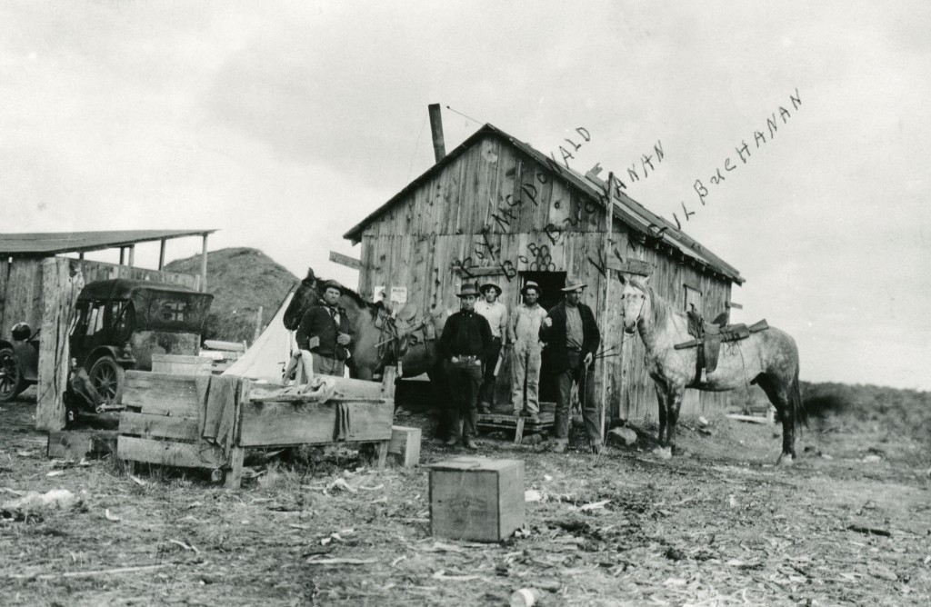
Loading logs with a McGiffert, at McCoy Flat, 1952.
While many are familiar with McCoy Flat Reservoir along Highway 44, there is another McCoy Flat in Lassen County, This too, was named for another Tehama rancher, Leo Lewis McCoy (1850-1936) who used this area for summer pasture from 1874 to 1913. When he retired in 1913, he sold his ranch of 27,000 acres to Alden Anderson for $150,000.
For the record, this McCoy Flat is located along Pine Creek, just east of Eagle Lake. In 1952, it was the scene of the last of the railroad logging operations of the Fruit Growers Supply Company.
In the fall of 1912, Benjamin H. Leavitt proposed the town on his original ranch. Leavitt wrote to his granddaughter, Edith Elledge, of his intentions: “I am going to cut the old ranch up into small tracts and sell it off in ten and twenty acre tracts . . . I am also building a road down from Rice’s Canyon, you know that is directly north of the town of Leavitt, to connect with all the northern trade clear out to Big Valley. The R.R. Co. have agreed to put their stock yards there. I have given them the land for the stock yards. I am also going to extend the road through the ranch to intercept the Janesville Road near Billey Indian. All the merchants of Janesville have agreed to order their good shipped to Leavitt which will make it one of the largest shipping points on the Fernley & Lassen.”
In addition, Leavitt offered railroad officials land if they would construct their roundhouse there. That proposition did not occur as Susanville’s business community convinced the railroad to locate that operation in their town. “The City” consisted of only the store, a few dwellings, and several large corrals that held livestock for shipment on the railroad.
Yet, years later, one could say a city of sorts of was built just north of Leavitt, the home of the California Conservation Center and High Desert State prisons.
One of many glyphs to be seen along Upper Smoke Creek.
In the 1960s, the newly organized Lassen County Historical Society published historical bulletins. In 1964, the Society released Petroglyphs of North Eastern California and Nevada by Tom Eilers. What Eilers ascertained like others, these petroglyph sites have one item in common-they were above the Lake Lahontan shoreline.
It is interesting that sixty years later when Eilers wrote his observations we still do not know a lot about them. Years later, Tom shared with me photographs he took of glyphs back then. Hopefully, after I am relocated and settled in, I scan share and post them.
This was a Pleistocene lake that covered a large portion of Northwestern Nevada and extended into parts of Northeastern California. Approximately 10,000 years ago, the lake began to recede, leaving behind remnants such as Pyramid and Honey Lakes. Lake Lahontan’s greatest depth was estimated at 920 feet at Pyramid Lake. To give a better perspective, locally, Susanville’s Elk’s Lodge, if it existed at the height of Lake Lahontan, would have been a beach front house. Around the Wendel region, but not excluding other locations one can see shore line terraces when the lake receded.
This map is illustrative about tomorrow’s topic: petroglyphs.
In the late 1940s, soap box derby races held in Susanville. In normal circumstances I would venture to the library to examine the Lassen Advocate newspaper on microfilm. I know this sound like broken record, but until my housing situation is resolved, it really limits my research ability. Who knows, there might be a reader could enlighten us. Anyhow, I thought there would be some that would enjoy this photograph.
This is a prominent feature of the old Bonham Ranch of southwestern Smoke Creek Desert. Early day travelers referred to it was Rotten Egg Spring, due to its sulfuric smell. Early day folklore stated that the spring was bottomless. Jack Bonham stated the spring had a depth of thirty feet.
There were a number of Hollywood films that used Lassen County locations in a number of movies. Susanville native, Ephie Asher, had a lot of influence as a Hollywood producer, and members of the Asher family are still in that business. One the last films shot here, was released in 1939 and called “The Good Samaritan.” Featured in the film was Antelope Grade and some scenes near Westwood. I have never had the an opportunity to research it further to ascertain about its availability, because it is one of those items that are on to do list, but never seem to get around to.
The interior wall at the Pioneer courtesy of Lassen Ale Works
For an unknown reasons, I have received several inquiries of Lassen County Brands. While in normal instances I would oblige, but due to the circumstances of pending my move, these will be put on hold and other requests until my life is stable. Thank you for your patience.
Red River operated numerous logging camps from 1913 through 1944 when it sold to Fruit Growers. The camps were assigned numbers, though in no particular order. The majority of the camps were short lived and only had a span of one to maybe three years. One of the more interesting camps was Camp 33, but referred to as Town Camp, as it was located less than a mile west of Westwood. What made it unique was that Red River’s company town of Westwood would experience from time to time a housing shortage for its employees.. On occasion, this camp was used to house mill workers instead of loggers.