B.F. Loomis and his museum

Loomis Museum, circa 1940

Prior to the volcanic eruptions, it should be noted, a movement had begun to make Lassen Peak and its many hydrothermal features a national park. The eruptions brought the area out of obscurity and in 1916 Lassen became a national park. Loomis with a handful of others were the park’s most ardent supporters. The park needed all the assistance it could get. One of the biggest problems was Congress never provided adequate funding. By the mid-1920s, a portion of the funding hurdle was resolved.

One of Loomis’ lobbying efforts was to have the park headquarters located somewhere in the Manzanita Lake vicinity. This was problematic on several accounts. First and foremost the original park boundaries did not include that territory. Nevertheless, Loomis persisted. Loomis had spotted a 40-acre parcel at Reflection Lake, not far from Manzanita Lake. Loomis informed the park he would purchase it and donate it to the park to be used for “administrative purposes.” In 1926, he bought the parcel for $1,000. The following year park officials announced that Mineral would be the site for the headquarters. 

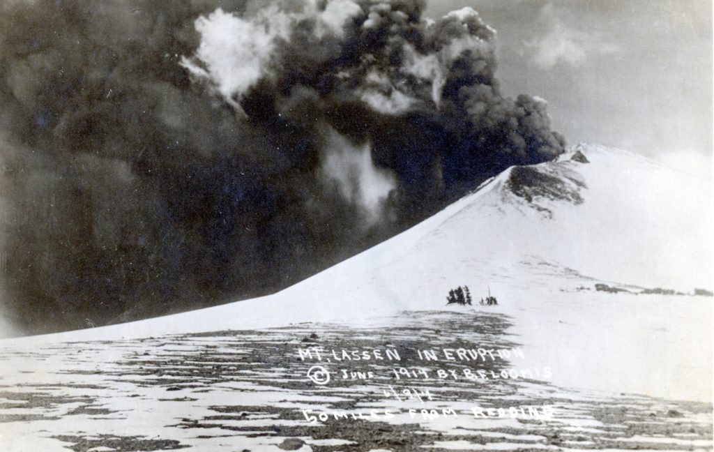
Loomis forged ahead and in 1927, he built a museum of native stone and reinforced concrete near Reflection Lake.  The museum served two purposes. One, it allowed him to showcase his famed photographic collection of the Lassen Peak eruptions, previously on display at his hotel at nearby Viola. The second reason was it served as a memorial to his only child, Louise Mae, who died in 1920.

In 1929, a park expansion bill was approved by Congress that would include the territory of Manzanita and Reflection Lakes. Loomis true to his word, in 1929 deeded his property to the park. Later that year, the park in consideration of the donation, granted Loomis a life estate to five acres that allowed him to continue with the museum and gave him the privilege to build a residence and photography studio. B.F. Loomis died in 1935, and his wife Estella in 1953.

Yet, the story does not end there. In the early 1970s, two geologists considered Chaos Crags a hazard, that a rock avalanche could threaten the facilities at Manzanita Lake and the Loomis Museum. As a result the park shut down those operations and eventually removed the buildings. Somehow, Loomis Museum was granted a reprieve. In 1993 the museum was fully rehabilitated and now operates on a seasonal basis.

Subscribe

B.F. Loomis and a story of jury duty

One of the many photographs Loomis took in June 1914

We are fortunate to have a bounty of museums in our region. Each one unique in their own special way. Equally important, all of them are worthy of a visit. Since this is July, there is no better time like the present to check them out.

One of the oldest museums is Loomis, located near the northern entrance of Lassen Volcanic National Park. Its founder, B.F. Loomis had an interesting association with the region. Actually, how the museum came to be is as intriguing as Loomis.

Initially, Loomis’ origins were rather typical of the era. He was born in Illinois and came to California as a child with his parents who settled in Tehama County. In 1874, Loomis had his first exposure in the area later to be destined Lassen Park. It was a camping trip to Manzanita Lake. The region suited him well and took up residence in nearby Viola. He made a living making wooden shakes, commonly used as roofing material. As he prospered he established a hotel at Viola.

In 1897, an event dramatically transformed his life—jury duty. Off to Redding Loomis went and there he met fellow jurist Leander V. Loomis. While the two men were not related, they both shared an interest in phrenology and astronomy. During a trial recess, Leander invited B.F. to his home. During his stay met Leander’s daughter, Estella. A romance ensued and they were married that fall. Leander had another child that influenced B.F.—Arthur who was a commercial photographer. Arthur introduced B.F. to the world of photography and years later B.F.’s photographs became widely known.

The next life changing event for B.F. Loomis came on June 14, 1914 after one of the volcanic eruptions of Lassen Peak. With camera in tow Loomis, as did other photographers captured the event on film. It should be noted the initial eruption occurred on May 30 and word spread like wildfire. Multiple news organizations were dispatched to report on the first active volcano in the continental United States. Loomis’ timing was impeccable and various news outlets used his images and Loomis gained a certain notoriety.

Subscribe

Answers to Some Questions

Amedee Hotel, 1910. Courtesy of Betty B.Deal

By coincidence I am working on feature article of the Amedee and Madeline Hotels for the Northern California Traveller. As to the Brubeck family, I am able to provide some insight, as years ago I corresponded with Leslie Brubeck, who was born at Amedee in 1900. In addition, a subscriber is going to make a journey to Brubeck Spring, so I will ask for a photograph to include in a future post.

As to the natural history of the flora fauna conditions prior to the settlement, that can be done in several installments. In the 1990s, I conducted extensive research of the vegetation of eastern Lassen County prior to extensive grazing of cattle and sheep. An interesting source were the field notes of the Government Land Office surveyors who included descriptions of what they observed during the initial surveys of the 1870s. Another example was when in 1854 Lt. E.G. Beckwith explored the region for a possible transcontinental railroad route. Members of his expedition studied and documented the flora and fauna they found.

Subscribe

Early forest fire origins

Prattville Fire burn, 1925

In the fall of 1899 various Northern California newspapers pondered the question of the causes of forest fires, especially during fall. The San Jose Mercury News blamed it on hunters. The Oroville Register stated it was the cattlemen who set the fires every fall. Susanville’s Lassen Advocate chimed in with this response: “Over this way it is the custom to charge the sheepmen with the forest fires. Some of the fires are doubtless due these different agencies, but not all of them. An old hunter “a man who has lived long in the mountains” tells us many fires are set by Indians. He says that in seasons when deer are numerous, as they have been in this season, they may be found in numbers where the underbrush has been burned off, disporting in the soft warm ashes and fall easy victims to the Indian hunters.”

Subscribe

Whaleback Fire Revisited

Whaleback Fire courtesy of InciWeb

It was a year ago, on July 27, 2018 that in the early afternoon a fire was spotted on Whaleback Mountain, just west of Eagle Lake. During its peak Spaulding Tract, Aspen Grove, Christie and Merrill campgrounds, along with the marina and Camp Ronald McDonald were evacuated. A voluntary notice was provided to Buck’s Bay and the Stones-Bengard subdivision. On August 8, 2018, the fire that destroyed 18,703 acres was fully contained. The origin of the fire was never determined or if it has not fully disclosed to the public.

Subscribe

A Sunday Drive – Antelope Lake

Antelope Lake, 2002

For many years, when my Mother was alive we would have the weekly ritual of a Sunday drive. During the summer months, we would make some extended loops. One of these featured Antelope Lake on the side of Diamond Mountain for those who reside on the eastern slope. This would entail leaving Susanville via Highway 36, then going along the east shore of Lake Almanor. Once in Indian Valley just past Crescent Mills is the turn off to Taylorsville and Antelope Lake. It is very scenic especially through Genesee Valley, then one makes the climb up the grade and at the top you are near the splilway of Antelope. The paved road meanders around the lake, eventually takes you to Janesville Grade.

Antelope Lake, by the way, is in Plumas County and is a popular recreational spot for a number of Honey Lake residents. It is part of the State Water Project of the California Department of Water Resources. The projects original intent was to provide water to Southern California to augment that of the Colorado River. Antelope Lake was constructed in 1964. There is a 113 foot tall earthen dam. The lake has a surface area of 931 acres with a maximum capacity of 47,466 acre feet.

Never miss a story, click here to support and subscribe.

A Scarlet Fever Panic

First Grade, Susanville Grammar School, 1914, teacher Mrs. Tom W. Wilson—B.R. Zimmerman Collection

It seems of late, that on a almost daily basis measles is in the news. There was a time when other communicable diseases made headlines. Locally, in the spring of 1916 a scarlet fever epidemic hit Susanville. Not to take any chances, school officials closed the Susanville Grammar School for a week, hoping that would be sufficient enough. It was.

Subscribe

Three Flags Highway

Doyle one of the many communities along U.S. Highway 395. Courtesy of Marie H. Gould

For many decades U.S. Highway 395 was referred to as the Three Flags Highway. The name representative that the highway began at the Mexico border and ended at the Canadian border. It had its humble origins in 1931 when a group of Lancaster, California businessmen as a way to promote the possibilities of a singular highway that traversed the east side of the Cascade and Sierra Nevada mountain ranges.

Subscribe

Interpreter Needed

Unknown grave, Susanville Cemetery, July 19, 2019

It must be the dog days of summer, or is it sleep deprivation with roofers by day at my chateau and the Susanville Main Street reconstruction project at night?

For a respite, I have been working in the Susanville Cemetery in the afternoons. It is quiet there and the inhabitants are quite pleasant. There are lots of interesting headstones to be found there. However, there are several that leave me puzzled. They basically consist of chunks of unfinished stone. The one above has a hole drilled through it.

In the past, I have had a good luck in seeking an interpreter on an unusual headstone since the headstone’s inscription is in Japanese. A Japanese Lassen College student came to my aid to translate. As to the other stone monoliths, I let you draw your own conclusion.

Never miss a story, click here to subscribe.

Where are we – Snowstorm Wetlands Habitat

June 21, 2019

The Snowstorm Wetlands Habitat is located between Horse Lake and the Snowstorm Ranch. In this view, one can see Fredonyer Peak in the background. From what I understand it was created in the early 1980s. I had never seen it before. However, I have travelled Horse Lake Road, in those instances it could have been in dry years when it had no water. It also more visible those traveling westbound as it is in direct line of vision.

Never miss a story, click here to subscribe.

Exploring Lassen County's Past