Tag Archives: Natural History

High Rock Springs

High Rock Spring, April 1975

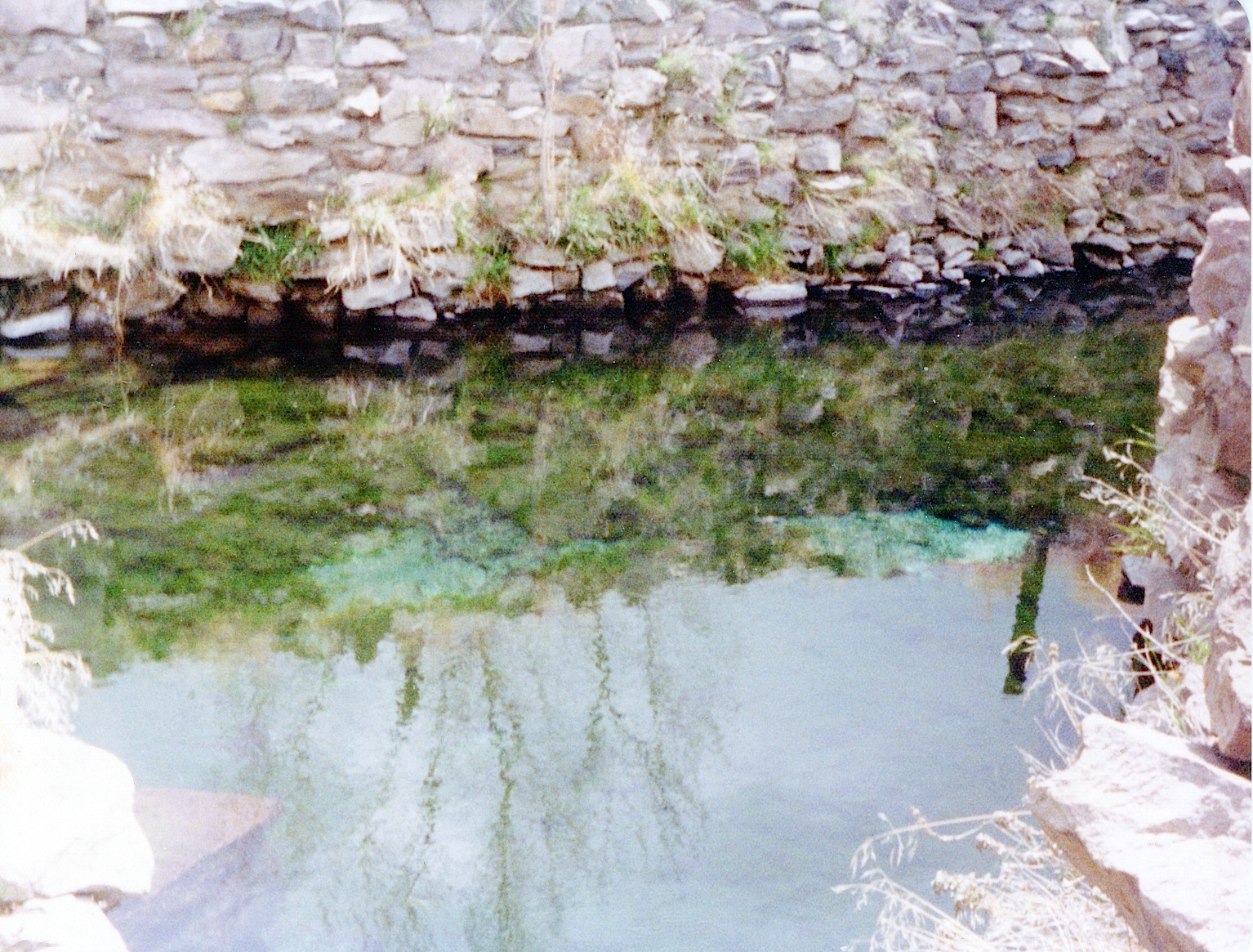
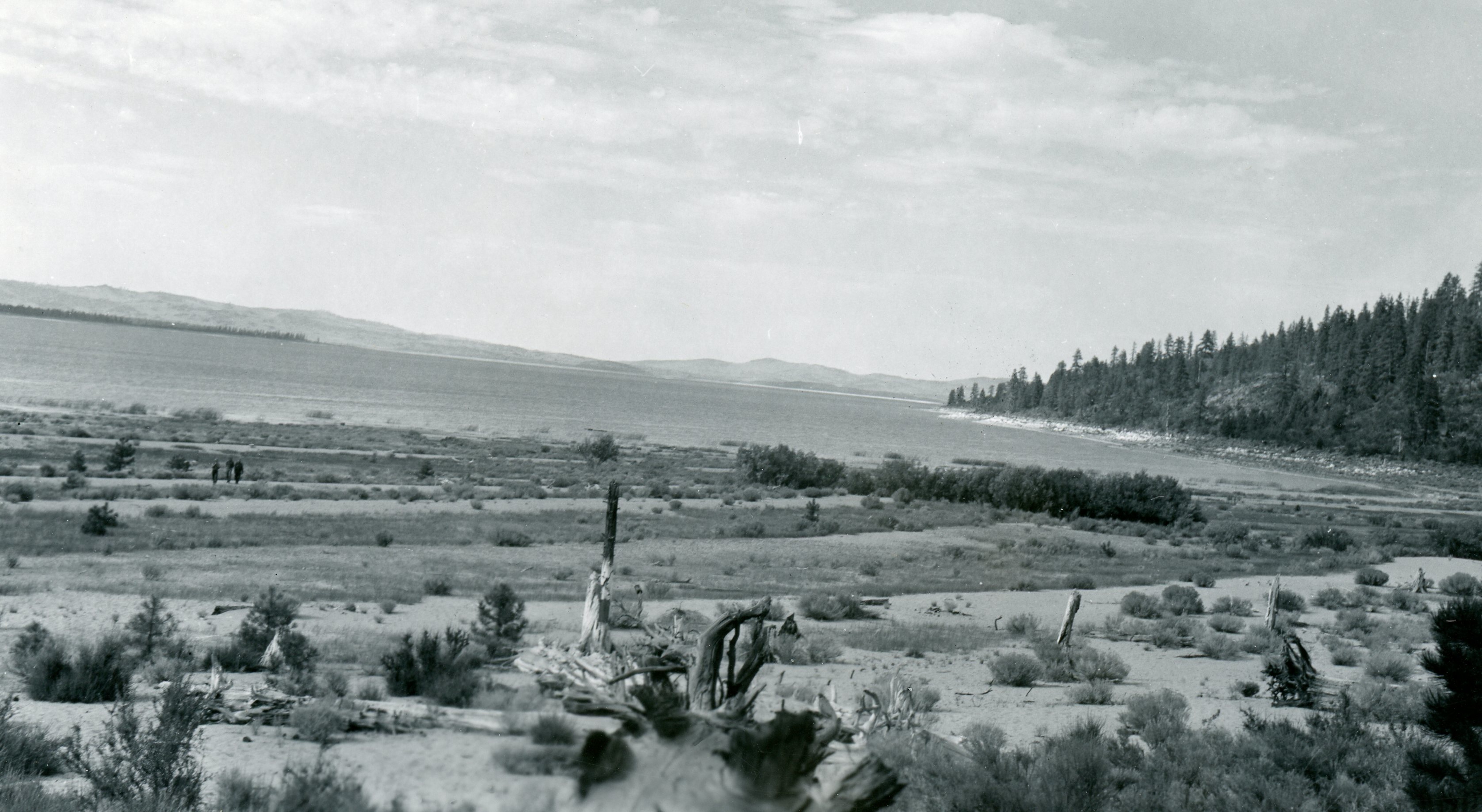
These springs in eastern Honey Lake Valley and near the Nevada border are quite unique. They are an ancient spring dating back to the time when the area was covered by Lake Lahontan in the Pleistocene epoch.

The second reason is it is a warm water spring with a constant temperature of 86F.  The springs supports two kinds of fish. First is the Lahontan tui chubs.  This, of course, is rather remarkable that the fish have adapted over the years to thrive in constant warm water in a confined space. Water from the spring then goes underground and re-surfaces 100 yards distant, maintaining a constant cooler temperature at 76F. At this point, again,which is also unusual, is found the Lahontan speckle dace.

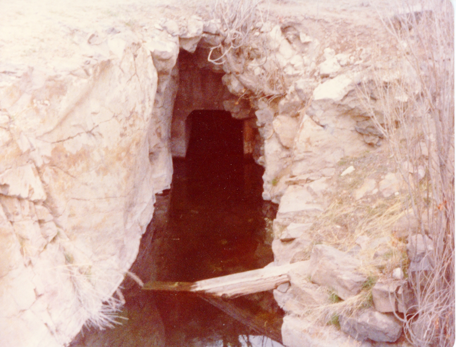
It should be noted that in the 1920s, William Dicting was hired by the Jenkins to develop the springs. He spent eight years to hand drill through the rock to develop the water tunnel to increase water flow.

A portion of the tunnel outlet of High Rock Springs. April, 1975

It is never too late, subscribe today and enjoy tomorrow with daily notifications. You can also surprise someone with a gift subscription.

Eagle Lake Biological Field Station

Eagle Biology372

At the October 2015 meeting of the Eagle Lake Interagency Board, the Bureau of Land Management reported that Chico State University was exploring avenues to close down the facility. At that time, the Bureau of Land Management reported that they would be willing to take back the property they donated to the University back in 1964. However, they stated in order to do so, the University would have to remove all improvements, i.e, buildings etc. At the moment, from my limited knowledge on the topic, it appears everything is at a standstill, as the University does not want to be burden with the costs of removal. It also appears the Bureau of Land Management is being a difficult, not allowing another institution to intervene.

The field station was the creation of biology instructor Doctor Vesta Holt. The first classes were taught at Spaulding Tract in 1945. In the early 1950s, with increased enrollment studies were moved to the south shore at the Eagle Lake Resort. After the Merrill Flat Fire of 1955, operations were moved to Susanville and Westwood and until a new home could be located. It was not until 1964, when a new home was located just north of the abandoned Bly Tunnel and in 1968 dedication ceremonies were held at the new facility.

It is never too late, subscribe today and enjoy tomorrow with daily notifications. You can also surprise someone with a gift subscription.

Russian Thistle

Litchfield Depot of the Fernley & Lassen Railroad, 1947. Courtesy of Camilla Moody

The Russian Thistle, (Salsola tragus), is best known too many as the iconic “tumbling tumbleweed.” Ironically, it became a symbol of the American West, yet it is a non-native plant. As its common name indicates it origins are from eastern Russia. Some sources indicate it was accidentally introduced in 1873 by Russian emigrates to South Dakota. The seeds from the plant are initially disbursed by wind. It is believed that many a railroad stockcar were imbedded with seeds, that allowed for them to be scattered throughout the west.

The plant did not make its appearance in Lassen County until 1914. While the Fernley & Lassen Railroad bought prosperity to the region, it also introduced this noxious invasive weed. The first plants were spotted along the railroad right-of-way. For the next two years, major efforts were undertaken to eradicate it, but it was a lost cause.

It is never too late, subscribe today and enjoy tomorrow with daily notifications. You can also surprise someone with a gift subscription.

Lassen County – Devil’s Corral

Devil's Corral Bridge, 1918. Courtesy of Margaret A. Purdy
Devil’s Corral Bridge, 1918. Courtesy of Margaret A. Purdy

The circumstances leading to its name are not known. There are two possible explanations. In 1865, San Francisco journalist Lisle Lester wrote: “Late in the afternoon we crossed a weird looking place of a rock wall enclosing a little flat meadow land called Devil’s Corral. The place is historical, for in the early days a band of emigrants stopped here to feed their stock and were overtaken by disease which covered the little nook with the bones of their cattle, and added to its soil many a way-worn form. For years the bones of the cattle bleached here in rude piles.”

In 1923, when the first highway bridge to span Devil’s Corral was completed, this published version made its debut: “The name was given the curious lava rock formation on the banks of the Susan River at this point by early day wagon trains who sought to reach the Sacramento Valley by following the course of the Susan River. At this point the perpendicular rock walls of the canyon made further progress impossible and they were forced to turn back, hence the name Devils Corral.”

It is never too late, subscribe today and enjoy tomorrow with daily notifications. You can also surprise someone with a gift subscription

Susan River, 1981

Susan River from the Carroll Street Bridge, 1981. Courtesy of Jim Cooper

While going through a photograph transfer file, in search of a particular photograph that I thought had been scanned, I came across this one of interest. By the way, for those inquiring minds, I never did find what I was looking for.

When I returned home a couple of weeks ago, I noticed the Susan River still had a pretty good flow, considering the circumstances of the drought. In the summer of 1981, gabions were installed along the south bank of Susan River just below the Carroll Street bridge to prevent further erosion of the bank. As one can easily see, there was not much water in the river to divert during the project.

It is never too late, subscribe today and enjoy tomorrow with daily notifications. You can also surprise someone with a gift subscription.

Eagle Lake’s Historic High Level

Notice how the water in this 1917 postcard is in the trees at the current marina site.
Notice how high the water is in the trees at the current marina site.

Note: While I am getting around better, I still have a long way to go. Some might have noticed that the published October Preview has deviated from what was intended. My apologies, but scanning images to accompany topics, has presented a challenge, due to my ongoing recovery from a broken hip. Please have patience sooner or later the intended topic will appear.

It is only fitting that a week ago, I attended the Eagle Lake Interagency Board meeting and yesterday’s Lassen County Planning Commission meeting. Since so much focus has been with drought levels of Eagle Lake, and groundwater basins, I thought let’s take a look at the other extreme. Continue reading Eagle Lake’s Historic High Level

Lassen County Deer Hunting

Deer Hunt
A successful hunt near Skedaddle, 1906. Courtesy of Marge C. Foster

Once upon a time, a person was not confined to deer hunting in a particular zone. By the 1940s with significant improvements to highways and automobiles opened a lot of territory to hunters, once the domain of locals.

The Fruit Growers Supply Company operated lumber mills in Hilt, Susanville and Westwood. While researching its history, I always came across some interesting material. Fruit Growers’ Annual Reports are a wealth of information. Before you think I am losing my sanity writing first about deer hunting and then lumber mills, there is a common thread.

The following is a most interesting excerpt from Fruit Growers’ 1946 Annual Report:

“Much of the country in which Company timber is located is considered to have good deer hunting, and the deer season opens at a time when the woods are in the driest conditions and when the fire hazard is the greatest. The handling of the large influx of people into the general Northern California area during the deer hunting season constitutes a very serious problems to all owners and agencies interested in timberlands. In 1946, hunters and their parties were registered as they entered Lassen County area, and during one week’s time, close to 5,000 automobiles and 13,000 individuals registered as potential deer hunters. Thus more hunters were checked into Lassen County than its normal population. Despite this, the Company was fortunate in its 1946 experience with forest fires.”

Subscribe and support this site for little as $4.17 a month.

Eagle Lake’s Historic Low

A view of Eagle Lake in 1950.

Yesterday, I attended the Eagle Lake Interagency Board meeting at Spaulding Tract. (It was my first public appearance since being home recovering from my broken hip, though I had to explain why I was using a walker.) Of course, one of the topics on agenda was the lake level, which is now at its all time record low of 5090.6 feet, just barely breaking its 1935 record. Whether or not the lake will recede even lower in the month of October is anyone’s best guess. While cooler temperatures will assist in the reduction of evaporation, the big factor will be whether any substantial precipitation will occur this month.

There were, of course, some lively discussions throughout the meeting. The eradication of brook trout from upper Pine Creek was news to me. I was later informed it has been issue for several years in certain circles. There was an item that was overlooked on the agenda, and I would have brought it up to the chairman, but I just did not have in me, due to the discomfort I experienced sitting, and needed to make a departure. The agenda item 2c – Update on new Stones lake level benchmark. However, I have a Lassen County Planning Commission on Wednesday, October 7, so I will ask then.

Hope with bringing you this information, it might just give you a tiny incentive to part with five dollars a month, to keep things afloat.

Random Notes

TR4
The TR4 before the Wolcott curse.

Good Monday morning. It is now mid-September, with fall fast approaching.  Actually in certain parts of the world, they do not necessarily observe the equinox/solstice and pronounce that the new season begins on the first of the said month. In this instance, fall begins on September, winter December 1 and so forth. There is some merit to this system, as the changes are already evident.

While reading the Reno Gazette Journal the other day there was an article about the Cascadian subsuction zone that could trigger a magnitude earthquake of 9.0 off of the Pacific Northwest ocean, which extends as far south as Mendocino.  The fault lines extend to Lake Almanor and points south. Of course, earthquakes and faults are one of the many topics for the Inspiration Point Tour.

Subscribe and not only support this  site for as little as five bucks a month,  but it also will assist me with my recovery.

Eagle Lake Water Levels

Gallatin Beach
Gallatin Beach, Eagle Lake, 1940. Courtesy of Lola L. Tanner

At the June meeting of the Eagle Lake Interagency Board meeting it was thought that Eagle Lake would reach a new historic low water level. On August, 31, 2015, Matthew May, Associate Lassen County Planner recorded the level at 5091.16, just shy of the record low of  5091. May noted that the level had dropped 2.4 inches in the last month. Stay tuned for further developments.

Once I have an opportunity I will post some photographs of the lake’s east shore taken in the 1930s by my grandmother Lola Murrer Tanner, who was born this day in 1899 at the family ranch in Willow Creek Valley. Also the 2016 Lassen High Alumni Calendar includes a new before published record high water scene taken in 1916, which will be released in October.

Help me with my recovery, and subscribe for as a little as $5.00 a month.