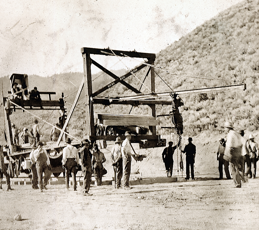
Construction of the Western Pacific Railroad near Constantia. Courtesy of Marie H. Gould
In 1907 the Lassen Advocate provided some interesting statistics concerning the construction of the Western Pacific Railroad (WP). The paper’s editor/publisher, E.W. Hayden, was fascinated that there were to be 75 bridges, most of which were west of Wells, Nevada. The aggregate length of these bridges was estimated at three miles, that would require 20,000 tons of steel to construct. Then there was the staggering amount of tunnels to be constructed. In a bit of tongue and cheek, Hayden suggested the WP should change its name to the B&T—Bridge and Tunnel Railroad.
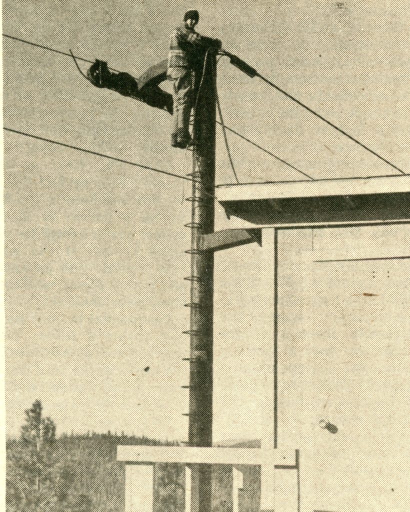
Mike Johnson, Lassen College student, checks a pulley atop the last post at the top of the mountain.
“This was our dream 30 years ago; to get a lift that would go clear to the top of the mountain, and where you didn’t have to hold onto a rope all the way.” Those were the sentiments expressed by Maurice Hertzig, Westwood’s Fire Chief and Harold Powell, Lassen College professor in December 1976 when nearing the completion of the Pomo lift at Coppervale. The new lift powered by a 60 horsepower electric motor, will rise 1,560 vertical feet up the mountain and have a capacity to move 550 people per hour. The three month construction project cost $29,000.
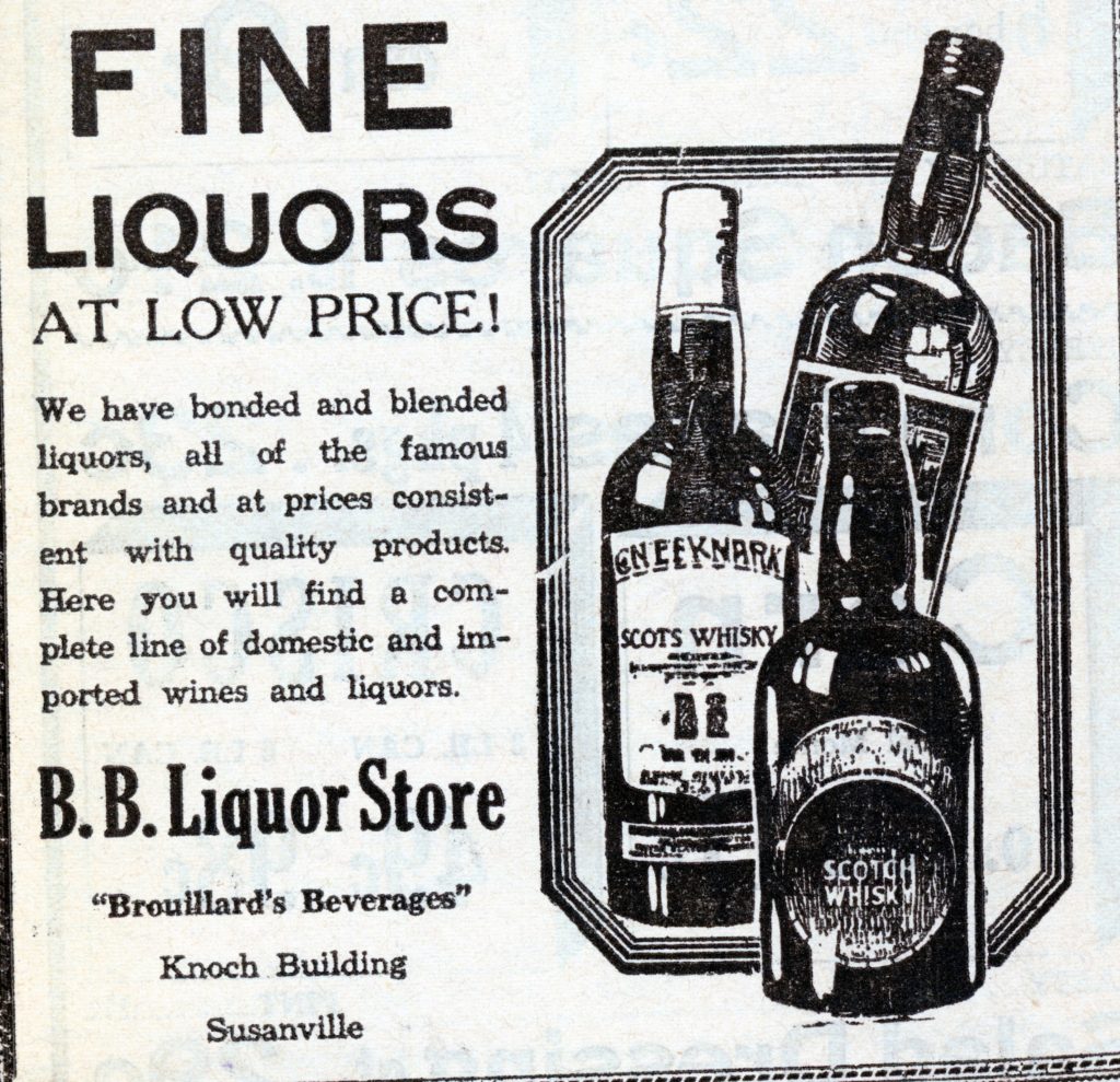
Seasoned residents will remember with fond memories of the B&B, a fine restaurant and bar located in the Knoch building. Before it became the B&B it as the B.B. Liquor Store. The B.B. stood for Brouillard’s Beverages, after the owner, E.H. Brouillard.
Some may recall in the banquet room, there was a rather large canvas mural 6’ x 20’ of Mount Lassen. It was painted by J.E. Lane, and the mural still exist, it being in storage. It should be noted that two other works of Lane have graced the walls of the Lassen County Courthouse since 1917. One is of Susanville as it appeared in 1864. The other is of Warner Valley, with Lassen Peak in the background. Why the County Board of Supervisors selected the latter has always confused me. First Warner Valley is in Plumas County. And, secondly, Lassen Peak is in Shasta County.
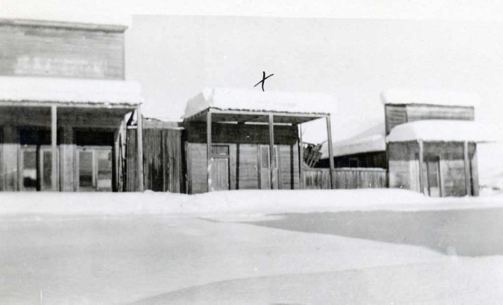
Amedee, January, 1911. The “x” indicates the town’s old dance hall. Courtesy of Madelyn Mapes Dahlstrom
According to the weather gurus, this week we may experience a decent storm. January, typically, is when some of the record breaking storms occur. Take for instance in 1911, when in one storm Susanville received eight feet of snow. What was truly remarkable was Amedee, on the desert east side of Honey Lake received the same amount. Johnstonville resident, Robert E. Trussell, who was fourteen at the time, recalled you could not see a single fence post in the valley.
Construction of the Fernley & Lassen Railroad, west of Susanville in eight feet of snow.
In January 1914, snow pummeled the region. This caught Southern Pacific Railroad officials off guard. Talk about panic mode, and they recruited 1,000 men to shovel eight feet of snow, so as to not hinder the construction of the railroad to Westwood, to honor the contract with the Red River Lumber Company.
North Pine Street, Susanville, January 1916
In January 1916, single storm dumped four feet of snow in Susanville. Westwood on the other hand had eight feet of snow. This storm was followed with bitter sub-zero temperatures. The snowstorm paralyzed the NCO railroad in eastern Lassen County that resulted in a twenty-one day blockade.
Last summer I had good intentions to visit various sites to take photographs of what they look like today. The Eagle Lake Golf Course of the late 1920s was one of them, but I never made it. However, the Whaleback Fire did hinder some expeditions. John “Burt” Christie, one of the early operaters of the Eagle Lake Resort, was an interesting figure at the lake’s south shore. Besides the resort, he eventually became the caretaker of Gallatin House and the Gallatin properties at the lake. Continue reading The Eagle Lake Golf Course→
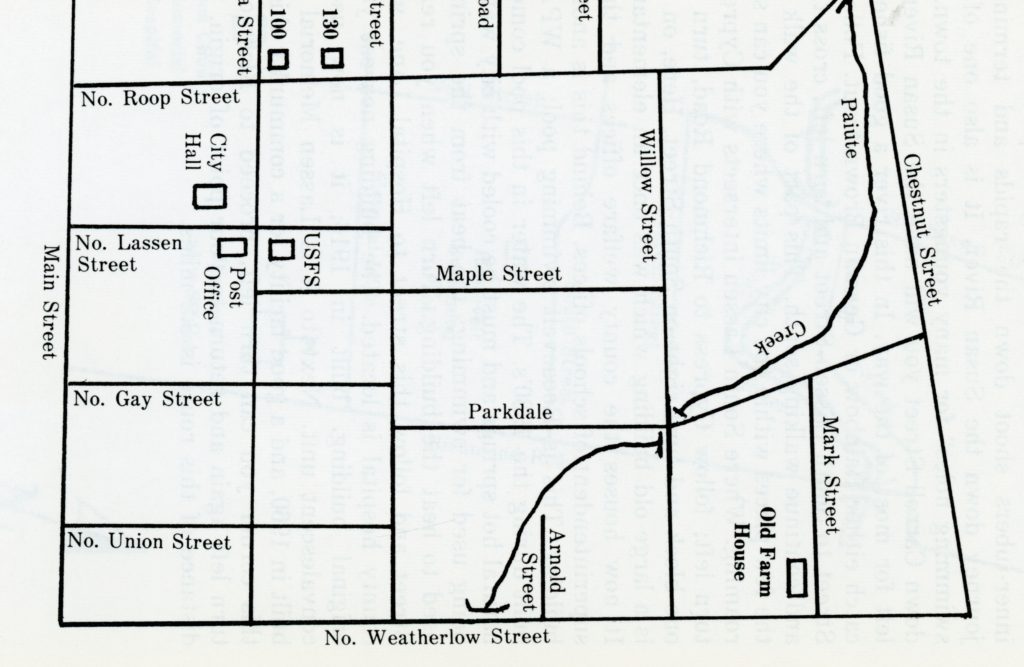
A sample map from Susanville Strolls. I might need some assistance to draft new ones.
First of all, I want to thank those for such wonderful feedback. Folks, I think we are not exploring Susanville’s neighborhoods, but all the wonderful regional trails and other kinds of self guided tours to be created. I am excited, and the possibilities are endless It will be my goal to create separate page for these self guided tours, so they will be easy to find. In addition, unlike print format, updates can be made, such if a walker sees something of interest, that could be included.
445 North Roop Street is the oldest “house” still standing and part of the red light district prior to the railroad. November 7, 2015
One route I have already plotted out mentally. Using the intersection of North Roop and North Streets as a starting point. It is interesting to note that the 200-300 blocks of North Roop contain a wide variety of architecture—bungalow, craftsman, Italianate, Queen Anne to post World War II residences, and a hodepodge in between. Continuing further down street, then making a turn onto Chestnut, overlooking what was once known as Vallejo Meadows. Thence from Chestnut, a right at Parkdale, which was created in 1947 and either to North or a detour to Maple Streets. This particular stroll is approximately one mile.
Roop Street Remains, September 3, 2018
Finally, those who want to join me while I do a preliminary runs, on any given route, let me know. My schedule is flexible, so I can accommodate.
The Honey Lake Valley is made up of various districts. Take for instance, the area along Highway 395 where The Mark is located as well as the Herlong access roads. This region is known as Bird Flat. In the spring of 1858, John Byrd settled at this location and brought with him 700 to 800 head of horses. That made him one of the largest stock raisers in the Honey Lake Valley.
T.N. Long-Courtesy of his grandson, Jack Howard Long
It should be duly noted, that Thomas Newton Long (1833-1917) is not related to the other Long family of Susanville. It is somewhat similar to the Doyle Doyles and the Milford Doyles, as they are not related, just makes things confusing.
This Alabama native came to Susanville in 1861 and with A.R. Leroy operated a saloon. He would have a colorful career in county politics when in the fall of 1867 he was elected sheriff of Lassen County and re-elected in 1868. In 1871 he ran for county treasurer and lost. In 1874 he was elected Lassen County Supervisor, District 1. In 1877, he was elected county treasurer and served one term. In 1882, he was elected Supervisor District 1 and remained in that capacity until 1900. Outside of county government he operated a livery stable and had a family of fourteen children. On footnote, the location of the livery stable, would later become the Telephone Building, and also the first location of Safeway.
Incorporated in 1890, the Honey Lake Valley Land & Water Company proposed the construction of a dam on Long Valley Creek to reclaim the desert lands of the eastern Honey Lake Valley. The dam and reservoir site was situated on lands adjacent to that of Long Valley pioneer George Greeno (1817-1902). In the summer of 1892, work began on the dam—90 feet high, spanning a 1,000 feet with a 500-foot wide base. It was estimated that the reservoir would have a storage capacity of 1,281 acres, at an average depth of 14 feet. The project had its skeptics, especially with the regional dam failures of 1890—those of Ward Lake and Skedaddle. The Lassen Advocate noted in October 1892: “The great interest centers in the permanency and holding capacity of the storage reservoir. Will it withstand the winter torrents and the rush of spring freshets? Will it successfully defy the incursions of insidious rodents and stand firm against the pressure of the floods? When the location of the dam is taken into consideration, the scientific, practical and thorough nature of its construction gives conclusive evidence that it will prove permanent.” The Advocate concluded “It has been filled little at a time by fine quality of clay, water poured upon it and then puddle by means of horses, which renders it impervious to water.” The region experienced an unusual amount of heavy fall rains that added a considerable amount of water to the nearly completed reservoir—a delight to many. In late November 1892, the area was hit a deluge, an estimated seven and half inches of rain fell at the dam site alone! The floods from Long Valley Creek breached the dam and left a gaping hole 100 feet wide. The damage was estimated at $50,000. The Company had invested over $175,000 in the project and never recovered from that loss. The Company’s manager, president and owner Fred Lake remained committed to the project until his death in 1942.
Any one who has ever been involved in a major water right battle that resulted in state intervention witnessed the production of an adjudication report. In the front of the report is a section called the “Duty of Water.” In certain ways the foregoing is not entirely relevant to the topic at hand. However, state never makes reference to the “Power of Water,” and when it strikes, what to do about it.
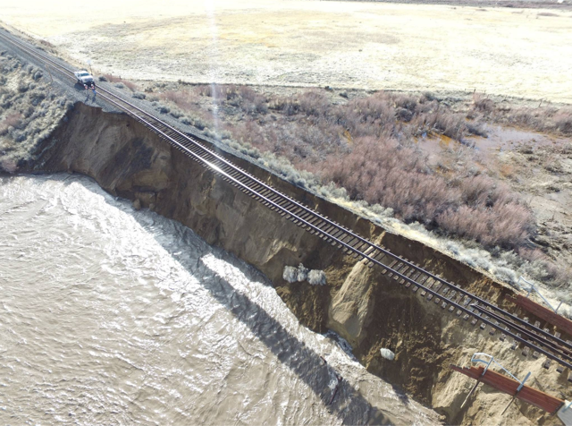
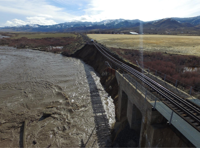
Long Valley Creek, January 2017
This post after all has a focus on Long Valley Creek, per a request of a flood during the early 1940s, though the particular date and/or other information is still being sought. For the most part it is hard to fathom that Long Valley Creek can be transformed into a raging torrent of water, when to the casual observer during the summer months, at time its flow can be a mere trickle. Yet, as one can see from the photographs shown, what kind of havoc this small stream is capable of. Tomorrow, we explore a proposed dam develop that was to harness the stream to provide water for irrigation.