A House Makeover

Ranker Residence—Ardell Torrey

Architecture is one of my many interests. Personally, much of today’s building designs are rather bland, whether commercial or residential. Today, we examine the Mattison house, which originally was not a stand out.

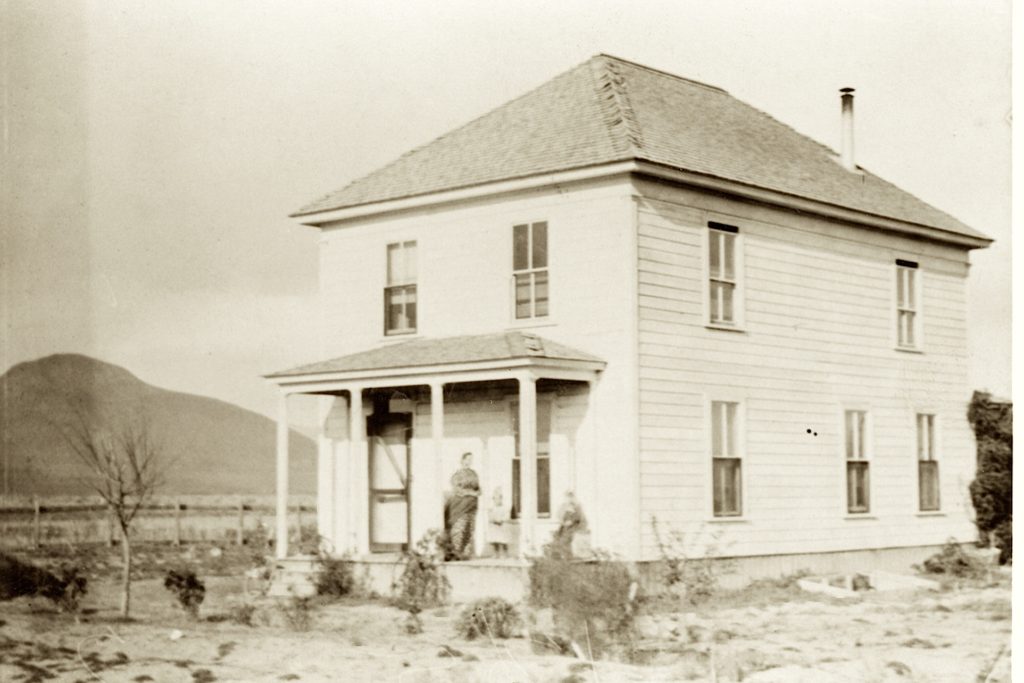
In 1879, Otto Ranker came to Susanville from Oroville to operate a blacksmith shop. In 1884, he located what was referred to as four corners, about two miles east of present day Standish. Like many homesteaders before and after him, he first lived in a small three room cabin. As needed, another room would be added, and so forth. In the early 1890s, he had a second story built that consisted of four bedrooms. In 1900, he moved to Chico for health reasons, but rented his ranch..

Mattison House
Mattison House, near Standish

In 1906, Ranker sold the property to Fred Mattison. Shortly afterwards Mattison had the house remodeled. Mattison died in 1926, but his wife’s family continued to occupy the property. In the early 1950s, during a cold winter the pipes froze. Hal Story crawled underneath the house with a blow torch to thaw the pipes. Instead, of thawing the pipes, he caught the house on fire and the residence destroyed.

Tim

Milford Street, Standish

Milford Street, Standish, 1908—Prentice Holmes

Tuesday’s are a wild card day, some times there is a post and some times not. For newer readers, when I started this site back in 2015, I did a daily post seven days a week. After five years, I scaled back to six days. However, I wanted to make sure something went on this Tuesday, to monitor the issue with the host sever.

The above photograph is Milford Street, Standish looking west, known today at the Standish-Buntingville Road or County Road A-3. The building to the right was the Wrede Hotel. It is now replaced with gas pumps at the Wayside.

Tim

July 4, 1920

Pine Creek Estuary, Eagle Lake—Verna Wood

This is certainly an unusual type of vessel or is it? I will leave it up your imagination. In the meantime, hoping everyone has an enjoyable Fourth of July. Personally, it is a quiet time for me, as I generally stay close to home on these kinds of holidays..

Tim 

Homer Lake, Lassen County

Homer Lake, Lassen County, 1919

It is one of three lakes on Keddie Ridge, the other two being Hidden and Deerheart.  The origin of the name is not known.  On December 24, 1878, G.A. Chipman and J.D. Anthony referred to it as Moon Lake when they claimed its waters for use on their Rising Star Mine. By 1881, it was being referred to as Homer Lake. By 1911, the lake had been planted with trout. In 1916, Frank Cady, who was deputy fish and game warden, first learned of the lake, and went to inspect the same as there rumors that unknown parties had dynamited the lake for fish. He found no evidence of same, and caught several trout weighing on the average of two pounds.

Homer Lake, July 2007

It is never too late, subscribe

Lake Almanor Causeway

Chester Causeway
Chester Causeway

In 1925, Great Western Power Company announced its plans to enlarge Lake Almanor. The raising of the dam would flood a large portion of Chester Flats, thus flooding a number of roads, and also Red River Lumber Company logging railroad network. Controversy arose when Great Western informed the Plumas County Board of Supervisors that the road across Chester Flats would be re-routed to follow the high water contour. The residents of Chester and Westwood were furious, for such a proposal would add an additional seven miles between the two communities. They wanted a causeway in which the current route would remain the same. Great Western balked at the idea. After all, a causeway would cost Great Western $220,00, while to re-route the road would only cost $50,000. To make a long story short the opponents bypassed the Plumas County Board of Supervisors and had the State Highway Department intervene. In 1926, an agreement was made between the State and Great Western that a causeway would be constructed.

Donate


Murrer’s Upper Meadow

Murrer’s Upper Ranch aka Meadow

Murrer’s Upper Meadow is an interesting place east of Eagle Lake. On the east side of the meadow is the headwaters of Willow Creek. On the west side is the outlet of Bly Tunnel. Up until the 1930s, the old highway route ran along the east side of the meadows.

About the place. In 1873, the Murrer family located at Round Valley, between Susanville and Willow Creek Valley. In 1876, the Murrer’s moved to their present location in Willow Creek Valley.

In the mid-1890s, the two Murrer Brothers—Jake and Edward began pursuing their own ranching efforts besides the home ranch. An opportunity came along to buy the meadows upstream from the home ranch. On September 24, 1898, the brothers  purchased the meadows from Robert Eddy for $1,200.

Jake resided at the meadows that the family referred to as the Upper Ranch. Jake is best known for an event that occurred there. On September 2, 1907, Jake literally blew up the five-room house he was living in. This feat was accomplished with twenty-five pounds of dynamite. The dynamite had been stored at the nearby Eagle Lake tunnel works of Merrill & Marker. When questioned about the explosion, Jake professed ignorance and stated he was lying on the sofa when the blast occurred. However, this could not be, as nothing remained but shattered pieces of the house with pieces of the fabric from the sofa hanging on the nearby cottonwood trees.
Continue reading Murrer’s Upper Meadow

Chester’s Lover’s Lane

Chester’s Lover’s Lane, circa 1914—Hazel York Moller
With the Fourth of July weekend approaching, Chester will more or less briefly become Plumas County’s largest community. Today’s photograph, however, was back in the day when Chester never witnessed a whole lot of folks at once. The postcard given to my by the late Hazel York Moller was taken circa 1914. Where Chester’s Lover’s Lane was back then is up to speculation, and whether Chester has a Lover’s Lane in 2022, I do not know that either. Its a big holiday weekend, so enjoy, but be careful at the same time. Tim

Fort Sage, Honey Lake Valley, Nevada

Von Schmidt's 1872 Map.
Von Schmidt’s 1872 Map.

This was an entirely different military encampment from its predecessors of the 1860s. It was never a fort, but a military camp. Military records refer to it as Camp Sage, but fails to provide dates of operation or an exact location, only township and range, the latter of which placed it eastern Honey Lake Valley on the Nevada side.  The camp’s sole purpose  was a rest stop on the military supply route from Reno, Nevada to Fort Bidwell, California. In June 1872, Perry Jocelyn was in charge of Company D, Nevada Calvary, marched the troops on foot from Reno to Fort Bidwell—a distance of 250 miles. The route went north and east of Reno over the Fort Sage Mountains, to the west side of the Smoke Creek Desert and then criss-crossing the California-Nevada border until it reached Surprise Valley. It was a difficult journey. Jocelyn found that out first hand, on the first day of the seventeen-day march, five soldiers deserted in the middle of the night. An attempt was made to locate them, but they were never apprehended. Unfortunately, Jocelyn’s diary only contained the following notation about the place: “June 2, 1872 – Rev. at 3. First wagon mired within one hundred yards of camp. At 8 o’clock train has not advanced more than one half mile. Cross large hill where it is necessary to double the teams. Newcomb’s ranch just on the other side with lake nearby. Four miles further with still heavier hills, Fort Sage is reached. The whole distance eight miles.” Continue reading Fort Sage, Honey Lake Valley, Nevada

A Tuesday Tidbit

Golden Eagle Mine,Hayden Hill circa 1890. Courtesy of Donna Howell

While the server is still working on the faulty email plugin, at least it is now functioning. I want to thank everyone for their patience during this unpleasant episode. Now,I can focus my energy on other matters such as the 2023 Calendar and with a little luck get summer exploring in.

Tim

Where Are We—Willow Creek

August 1, 2016—Annie Henriques Blank

The headwaters of Willow Creek is off the beaten path. Since the inception of tapping Eagle Lake for irrigation in the 1870s, its natural stream channel provided for the perfect conduit for the water flow from a Eagle Lake tunnel to the Honey Lake Valley. The spring located at Murrer’s Upper Meadow, a future post is scheduled on that topic, was just a short distance from Eagle Lake. The biggest obstacle, of course, was the tunnel construction. The original Merrill tunnel outlet was only a mile or so northwest of the headwaters of Willow Creek. When the Bly tunnel was completed, it was due west of the headwaters on the opposite side of the meadows.

Tim

Exploring Lassen County's Past