Tag Archives: Natural History

Honey Lake, 1859

Honey Lake, 1938

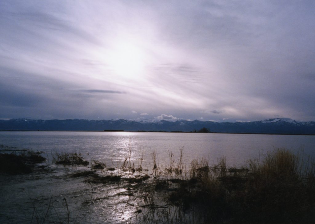
A strange thing happened in the fall of 1859 that took the residents of the Honey Lake Valley by surprise—Honey Lake went dry. For the Anglo residents this had never happened before. In addition, in 1856 two people drowned in the lake. This led to all kinds of theories as to how this could have happened.

Personally, I enjoy newspaper writers of the past for their wit. On October 29, 1859, Oroville’s Butte Democrat newspaper entered in the discussion and wrote: “Some of the papers are endeavoring to account for the sudden disappearance of the waters of Honey Lake. One editor suggests that they have sunk into vast fissures of the earth, caused by an earthquake. This theory might be objected to on the ground that if such fissures had been created, water would more probably arise therefrom than descend. Our deliberate opinion, formed after the most mature reflection and consultation of the most learned authorities upon the subject, is, that the waters which constituted what was formerly Honey Lake, have been drunk by the “Guyas Custas.” We shall prepare a paper upon this subject, to be deposited in the archives of some Historical or Geological Society.”

Donate

Susan River Dam Proposals

Crazy Harry Gulch, June 4, 2020

During the late 1880s during the dam building frenzy throughout the region, I thought it was always rather peculiar that a dam was never built in the Susan River Canyon. There was one proposal to place a dam just below Devils Corral, but nothing materialized.

In Lassen County’s 1968 General Plan it proposed to dam the Susan River at Devils Corral. It was the county’s belief that not only would be beneficial for irrigation, but for recreational purposes as well. The same report also proposed a dam on Willow Creek, just below Petes Creek. Of course, neither of those two propositions transpired.

In 1987, a proposal was made to dam the Susan River near Crazy Harry Gulch, about eight miles west of Susanville, for hydroelectric power. Tudor Engineering of San Francisco , proposed a 170 foot high dam, at a cost of $30 million.  This, too, never materialized.

Donate

Poison Lake, Lassen County

Poison Lake
Poison Lake, 1916

A shallow lake, along Highway 44, with water that was found to be unfit to drink by the emigrants on the Lassen Trail. The travelers also found that Lassen’s Trail was not “fit” for travel either. According to the journal of Gorham Gates Kimball who was driving sheep to Idaho in 1865, it mentioned that Poison Lake ‘was so named from the effect of the bites of small red spiders which frequented the surface of the water.’ Apparently, merely washing your face and hands was enough to receive bites and experience red inflammation.

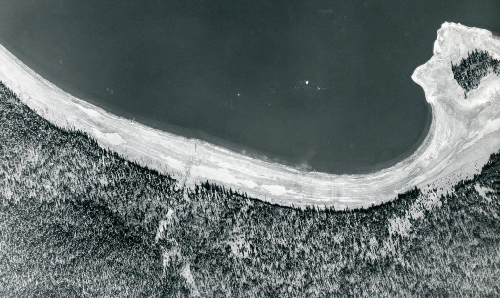
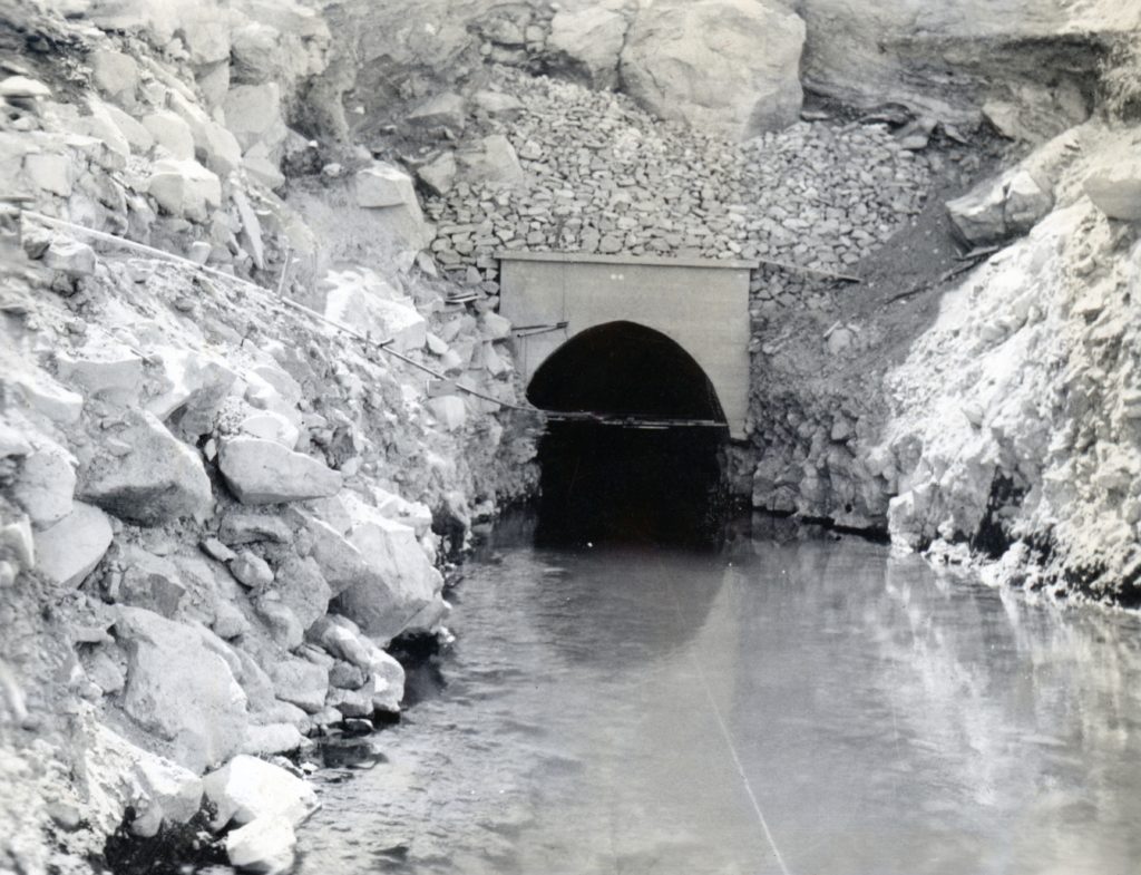
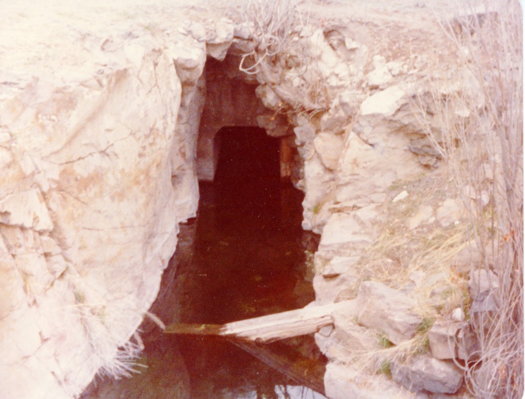
In 1916,  William L. Wales, an engineer hired by the Honey Lake Valley Irrigation District, took the above photograph, as part of his exhaustive study to seek water. He proposed diverting annually 33, 962 acre feet from Butte Lake, (no one had ever filed a water right claim to it) . A canal would be constructed from Butte Creek to divert it to Poison Lake, thence onto to Pine Creek to Eagle Lake, through a tunnel there and onto the Honey Lake Valley. Very clever. However, the district was plagued with so many problems in the beginning that it never went past the initial study phase.

Spread the word, and encourage a friend to subscribe

Forest Service Aerial Mapping Program

Forest service aerial of the south shore of Eagle Lake taken on 11/9/1941 from Flight No. 44—Hank Martinez

In the fall of 1941, the Lassen National Forest implemented the use of aerial photography as a tool to manage the forest’s resources. However, while the aerial mapping was completed, the outbreak of World War II suspended the work.

In February 1946, the project was brought back to life, to utilize the aerial photography taken five years ago. The forest service was pleased with the program. One of the many benefits, was that forest service personnel could conduct other kinds of field work than surveying during the summer. In the winter months, the aerials provided work for staff to plot out and design new roads, etc.

Subscribe

Elk for Lassen County?

Where the buffalo and elk roam at Wingfield Ranch. Courtesy of Lola L. Tanner

On September 23, 1912 J.S. Hunter the head of California State Fish & Game Commission paid a visit to local game warden Frank Cady. Hunter had been a frequent visitor of Lassen County to inspect different aspects of wildlife. He informed Cady that he thought that  the commission should plant a herd of elk in Lassen County. Hunter stated that government preserves had an abundant supply of elk and thought they would thrive in this region. In addition, Hunter recommended the planting of pheasants.

While the state never introduced elk to Lassen County, George Wingfield brought in elk and buffalo at his ranch at the the base of Diamond Mountain. After Wingfield sold his ranch, the buffalo were taken to Reno. In time, the elk roamed the region with reports that the last one killed about 1940 on nearby Bald Mountain.

Subscribe


Pit River Falls

Pit River Falls, circa 1915–Lola L. Tanner

Once upon a time, to leave Fall River Mills to head west to the Sacramento Valley, one travelled over Winters Toll Road through the Pit River Canyon. The toll road was built in the 1870s by Frederick Knoch and his brother-in-law, Deidrick Murcken for $3,000. In 1930, the route was abandoned when Highway 299 was constructed. I understand now that this is popular with whitewater kayakers. I never been to Pit River Falls, though it is part of my family’s heritage, since Knoch, was my great-great-grandfather.

Support this site and Subscribe today!

A Controversial Light (Control) Burn

Clear Creek, circa 1906. Courtesy of Mark Reed

In the past we have explored the topic of control burns by the Red River Lumber Company. With the fire situation at hand, this is going to be discussed widely across the West.

First a bit of background. Clinton Walker, a member of the family owned Minnesota based Red River Lumber Company came to California in 1899 to examine timberland as part of a westward expansion. By 1908, the Company had acquired nearly 800,000 acres of timberland primarily in Lassen, Plumas, Shasta and Siskiyou Counties. Long before the Company cut down a single tree, it had been conducting light/control burns throughout its holdings.

In the spring of 1912, Clinton Walker had planned to do a control burn at Clear Creek, Lassen County. He invited both state and federal foresters to observe. Coert DuBois of the U.S. Forest Service led the call to inform Walker to cease and desist and not do it. Walker ignored their pleas and it went ahead as schedule. He did invite those foresters to attend and they reluctantly showed up. They documented the event by taking notes and photographs (would that be a treasure to locate). Dubois who had been critical of the Walkers and their methods, routinely wrote opinion pieces in the west coast newspapers. He did a 360 degree, and complimented Walker on his systematic light burning approach.

Things changed quickly. The following year, Clinton Walker left Red River over a dispute with the family about its operations. Thus, the light and control burns were suspended. Twenty years later, Clinton would return. At that he time lamented about the neglect of their forests and wrote: “I have never been able to understand why, when we had successfully proven the feasibility of the work of control burns and its advantages, that we discontinued it. In this regard I think we committed a grevious error that has already caused us staggering losses and now have our forest in a very precarious condition.”

Support

CDF’s Willow Creek Station

The abandoned CDF Station, Willow Creek Valley, May 1978

In 1935, the Lassen County Board of Supervisors passed a resolution for the establishment of Civilian Conservation Corp camps (CCC) throughout the county, including one at the upper end of the Willow Creek Valley, between Susanville and Eagle Lake. The resolution stated would have “great value” to protect the timber. In addition, the men employed could aid the region with soil erosion  and related issues. The resolution was sent to M.B. Pratt, forester for the California State Division of Forestry. Pratt informed the board it could not assist with CCC camps at that time, due to Congress failure to pass a funding bill.

The Lassen County Board of Supervisors were persistent in their efforts to have fire camps established. In July 1937, State Ranger J.W. Nevius announced the established of four fire camps for Lassen County. One was for Willow Creek Valley and it was agreed the county would donate 2.5 acres to the State Division of Forestry that included the former home of C.E. Hurlbut. The initial Willow Creek workforce consisted of Charles Windamier, foreman, Harry Fox, cook, and crew members John Patten, Max Reedy, George Ross and Arthur Dixon.  John Webb who worked there in 1945 recalled, “My first assignment was at the Willow Creek CDF camp. I recall there was one permanent building used as a office and mess hall. Sleeping quarters were in tents erected on wooden platforms.”

As  it  appeared on August 9, 2018

In 1948, a fire station was established further north near Grasshopper Valley and the Willow Creek camp was subsequently closed. In 1974, the state donated this parcel to Lassen Community College.

Support

A Honey Lake Story

Honey Lake, 1997.

While researching Granite Creek Station, I came across some correspondence with Jesse Horn. He was a grandnephew of Andrew Litch, one of the proprietors of the Station. Horn was born at Milford on May 25, 1912. On February 25, 1980 Jesse Horn, wrote:  “An old Piute Indian from Nevada told me a story you might be interested in. At the time I was quite a small boy and as our custom was with the Indians, a sort of variation of a peace pipe. We cut a watermelon and ate it with him. This served two purposes for us; they didn’t steal our watermelons and they gave us their business.

This is what he said as he pointed across the lake to the Skedaddle Mountains. “See high water marks on mountain? Old Chiefs say many, many moons ago, no one can count. Great spirit get mad. Honey Lake that time, she big like many waters cover all valley, make Tahoe look like a pond. There was great big earthquake, thunder, lightning. Whole world shake mountains fall apart. Honey Lake break loose and make Pyramid Lake. All big fish go there.’”

Support

Blind Fish & Tunnels

Bly tunnel inlet, July 1924. Courtesy of Wyn Wachhorst

Over the years I have fielded a wide variety of research requests and still do. With that in mind, we explore two different inquiries one dealing with the Bly Tunnel and the other at High Rock Springs.

In August 1990, Peter Moyle of the University of California, Davis wrote, “I spent four weeks this summer at the Eagle Lake Field Station teaching a field course in fish biology. One of our class expeditions was to the tunnel, to check out rumors that it contained “blind cave fish.” To our surprise, it did have fish although they were the same species found in Willow Creek. We also found that the chemistry of the water is the same as that of Eagle Lake, so the tunnel is still a chain on the lake.”

High Rock Spring, April 1975

In February 2021, Zachary Bess, wrote, “I am a fish biologist with the University of Nevada Reno. I am currently working on a multi-year publication project concerning all of the native fish species in Nevada. Your webpage is the only page on the internet where I have ever seen an actual picture of High Rock Springs!

“To my understanding, High Rock Springs tui chub went extinct in 1989 when tilapia were accidentally introduced to the spring in an attempt to begin a fish farming enterprise. This is mentioned in several agency documents from the 1990s. It was a genetically unique type of tui chub and was actually a candidate for listing with the US Fish and Wildlife Service prior to its extinction. I was interested in going out there to see if the speckled dace are still in there just out of curiosity.

“Eagle Lake is the only place on the eastern side of the Sierra where rainbow trout are found naturally. The Pit River and Lost River have several species that are only found in these water bodies. The fish in High Rock Springs were similarly unique considering that they got in there by means of Lake Lahontan.”

Support