Tag Archives: Eagle Lake

Desert Homesteaders

This weathered sign of the NCO was updated to show that its headquarters had moved from Reno to Alturas. Photograph taken by Lassen County Librarian Lenala Martin at Wendel, 1920.

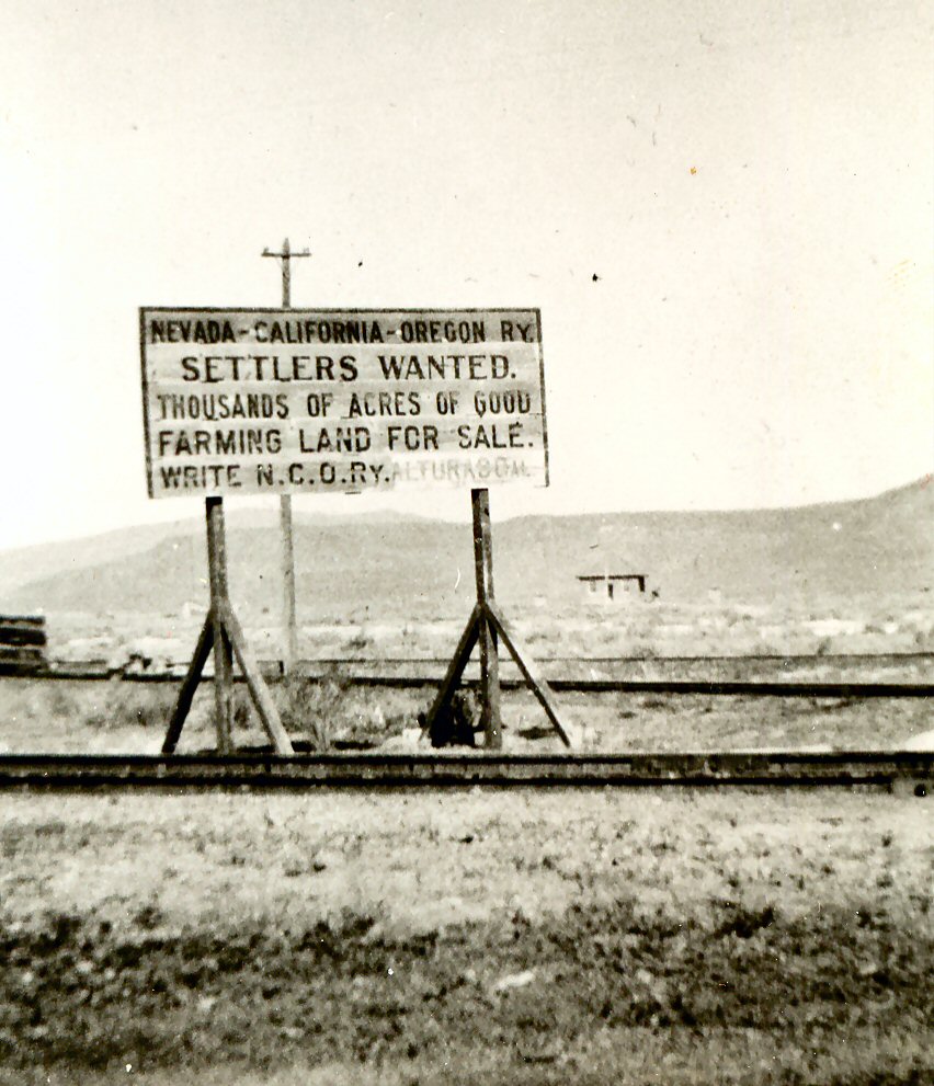
Amedee served as a hub for a number of reclamation projects that all held the belief that they were going to transform the eastern portion of the Honey Lake Valley into a garden oasis. These companies were persistent with their proposals. Initially, the optimism ran so high that the water from Eagle Lake would not be needed from the other reservoirs being constructed that its water could keep Honey Lake full for the Amedee Yacht Club.  However after several decades reality set in and the region would remain a vast sagebrush plain.

In the early 1900s there were several other factors that seem to make the desert bloom.  It was like a harmonic convergence where so many things came together at the same. Well-drilling had greatly improved, an extreme wet cycle in annual precipitation, the sugar beet industry, a second railroad and the Standish Water Company irrigation plant and canals. Stay tuned for further developments.

It is never too late, subscribe today and enjoy tomorrow with daily notifications. You can also surprise someone with a gift subscription.

Eagle Lake Biological Field Station

Eagle Biology372

At the October 2015 meeting of the Eagle Lake Interagency Board, the Bureau of Land Management reported that Chico State University was exploring avenues to close down the facility. At that time, the Bureau of Land Management reported that they would be willing to take back the property they donated to the University back in 1964. However, they stated in order to do so, the University would have to remove all improvements, i.e, buildings etc. At the moment, from my limited knowledge on the topic, it appears everything is at a standstill, as the University does not want to be burden with the costs of removal. It also appears the Bureau of Land Management is being a difficult, not allowing another institution to intervene.

The field station was the creation of biology instructor Doctor Vesta Holt. The first classes were taught at Spaulding Tract in 1945. In the early 1950s, with increased enrollment studies were moved to the south shore at the Eagle Lake Resort. After the Merrill Flat Fire of 1955, operations were moved to Susanville and Westwood and until a new home could be located. It was not until 1964, when a new home was located just north of the abandoned Bly Tunnel and in 1968 dedication ceremonies were held at the new facility.

It is never too late, subscribe today and enjoy tomorrow with daily notifications. You can also surprise someone with a gift subscription.

Eagle Lake’s Historic High Level

Notice how the water in this 1917 postcard is in the trees at the current marina site.
Notice how high the water is in the trees at the current marina site.

Note: While I am getting around better, I still have a long way to go. Some might have noticed that the published October Preview has deviated from what was intended. My apologies, but scanning images to accompany topics, has presented a challenge, due to my ongoing recovery from a broken hip. Please have patience sooner or later the intended topic will appear.

It is only fitting that a week ago, I attended the Eagle Lake Interagency Board meeting and yesterday’s Lassen County Planning Commission meeting. Since so much focus has been with drought levels of Eagle Lake, and groundwater basins, I thought let’s take a look at the other extreme. Continue reading Eagle Lake’s Historic High Level

Eagle Lake’s Historic Low

A view of Eagle Lake in 1950.

Yesterday, I attended the Eagle Lake Interagency Board meeting at Spaulding Tract. (It was my first public appearance since being home recovering from my broken hip, though I had to explain why I was using a walker.) Of course, one of the topics on agenda was the lake level, which is now at its all time record low of 5090.6 feet, just barely breaking its 1935 record. Whether or not the lake will recede even lower in the month of October is anyone’s best guess. While cooler temperatures will assist in the reduction of evaporation, the big factor will be whether any substantial precipitation will occur this month.

There were, of course, some lively discussions throughout the meeting. The eradication of brook trout from upper Pine Creek was news to me. I was later informed it has been issue for several years in certain circles. There was an item that was overlooked on the agenda, and I would have brought it up to the chairman, but I just did not have in me, due to the discomfort I experienced sitting, and needed to make a departure. The agenda item 2c – Update on new Stones lake level benchmark. However, I have a Lassen County Planning Commission on Wednesday, October 7, so I will ask then.

Hope with bringing you this information, it might just give you a tiny incentive to part with five dollars a month, to keep things afloat.

Eagle Lake Water Levels

Gallatin Beach
Gallatin Beach, Eagle Lake, 1940. Courtesy of Lola L. Tanner

At the June meeting of the Eagle Lake Interagency Board meeting it was thought that Eagle Lake would reach a new historic low water level. On August, 31, 2015, Matthew May, Associate Lassen County Planner recorded the level at 5091.16, just shy of the record low of  5091. May noted that the level had dropped 2.4 inches in the last month. Stay tuned for further developments.

Once I have an opportunity I will post some photographs of the lake’s east shore taken in the 1930s by my grandmother Lola Murrer Tanner, who was born this day in 1899 at the family ranch in Willow Creek Valley. Also the 2016 Lassen High Alumni Calendar includes a new before published record high water scene taken in 1916, which will be released in October.

Help me with my recovery, and subscribe for as a little as $5.00 a month.


Big Valley Toll Road


Big Toll Road
This hand drawn map, was made part of the company’s Articles of Incorporation.

In 1870, when gold was discovered at Hayden Hill, it was only a matter of time for some enterprising entrepreneurs to come up with plan to make money on this new gold rush. In this case it was John Watts, David Watson and Benjamin Neuhaus. On April 24, 1871, they incorporated as the Big Valley Toll Road Company. The road would begin at the Neuhaus’ ranch (Murrer) in Willow Creek Valley, then north along Eagle Lake, Grasshopper Valley to Hayden City, then to Hayden Hill with a terminus near Adin. These “dreamers” hoped to raise $40,000 in stock to finance their endeavor. While the concept on paper had merit, in reality it was doomed to failure, as it was already an established road. In 1875, the Lassen County Board of Supervisors declared the route as a public thoroughfare. Portions of the original route would eventually become part of State Highway 139.

Subscribe and support this site for as little as $4.17 a month.

Eagle Lake Bass

EL Bass
Guy Talbott with his Eagle Lake bass catch, 1918

Between 1879 to 1956 there were officially twelve different exotic (non-native) species of fish planted in Eagle Lake. Yet, that figure could be higher since local anglers were known to have experimented with their own plantings.

Of all the varieties of species planted in the lake, only one truly flourished—the largemouth (black) bass. In 1901 the Lassen County Fish and Game Protective Association planted 147 bass in the lake that it had received from the California Fish & Game Commission. The following year additional bass were planted in the lake. To allow the bass to prosper the State Game Commission prohibited fishing of the bass for a period of four years. Continue reading Eagle Lake Bass

Leon Bly

Leon Bly
Leon Bly sounding Eagle Lake. Courtesy of Wyn Wachhorst

It is only fitting to note that today’s marks the 100th anniversary when Leon Bly embarked on sounding Eagle Lake to determine the feasibility of an Eagle Lake irrigation project. Since the 1870s, there had been numerous failed attempts. No one knew the true depth of the lake, though many presumed it had depths ranging from 300 to 1,000 feet. Bly spent the summer sounding the lake in Oscar Rankin’s The Pelican and determined the lake’s deepest point at 105 feet, but felt the lake had potential as an adequate water supply for an irrigation project.

Of note, up until the 1980s, this boat was undergoing restoration at Janesville, but since it is not known what became of the project.

Support this site, Subscribe today.

Albert Gallatin

Albert Gallatin
Albert Gallatin courtesy of Wyn Wacchorst

Gallatin is one of the many intriguing figures in California history. This native New Yorker arrived in California in 1860, and the following year located at Sacramento. It was fortunate timing on his part to land a job in hardware store owned by Huntington & Hopkins. At the same time, Huntington and Hopkins would join forces with Crocker and Stanford, to become the “Big Four” and establish the Central Pacific Railroad. As a junior partner in the hardware business, became quite lucrative providing materials for the railroad. In 1877, he built the Gallatin House and in 1903 it became the California Governor’s Mansion.

The prosperous Gallatin began branching out into numerous endeavors including the sheep business. Gallatin needed summer range for the sheep, and discovered Eagle Lake. In a two year period in the late 1880s he purchased nearly 5,000 acres of Eagle Lake properties for $9,000. The bulk of the purchases were timberlands, with the exception of Hall’s Papoose Meadows and William Dow’s ranch near present day Spaulding Tract.

With the exception of Gallatin being Eagle Lake’s largest property owner, his influence otherwise was minor. In 1905, he passed away and his second wife, Malvena, had the lasting impact on Eagle Lake. After all she introduced Leon Bly to Eagle Lake.

Support this site, Subscribe today.