The current precipitation water year ended on September 30, and now begins a new year. According to California Water Watch Susanville received, or more precisely at the airport, which is Johnstonville recorded 19.07″ of rainfall. Accordingly it is 116% of average and the average being 16.38.” However, if one resides at the base of Diamond Mountain or even in Susanville proper the precipitation totals will be greater.
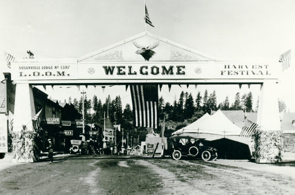
The arch was a temporary affair, and a windstorm two weeks later, blew it over.
Those who reside or have resided on the east slope of the Sierra Nevada know all too well that they are prone windstorms. Some areas worse than others.
On September 18, 1914, a particularly strong windstorm hit the region. One account reported that dust from Susanville’s Main Street was so bad, that occasionally one could not see buildings on other side of the street! Numerous reports of damage to Susanville businesses were reported, chief among them was large plate glass window that was recently installed in the Del Mar Building was shattered. Just over two weeks ago the local Moose Lodge sponsored a Harvest Festival and placed an arch at the intersection of Main and Gay. It was toppled.
Trees were uprooted and damage to fruit crops was extensive. A.H. Taylor, whose apple orchard on North Westherlow Street was a victim. He estimated 100 boxes worth of apples were blown off his trees.
Today, marks the beginning of meteorological spring. If you have lived around these parts for very long, winter and spring are very unpredictable.
This past winter was of no exception. It was a very rainy November and December, followed a by cold, dry January. The first half of February was a weird. Take for instance, February 6. The forecast, high elevation snow. In Susanville, by 8 a.m. it was snowing ever so lightly. By noon, it was still snowing. However, at the same time, it was not only raining in Truckee, but on Donner Summit. By late afternoon, it was still snowing in Susanville, but snow conditions to our north got worse. By 4 p.m. Interstate 5 was closed at Yreka due to snow, while it was still raining on Donner!
Yesterday, it was spring like in Susanville and the temperature broke 60F, the first time since early November. Today, the forecast is a repeat, and then a stormy pattern resumes. Appreciate the good weather wherever you live.
Typically, the largest snowstorms in this region occur in the month of January. It was January 1914 that proved to be a record breaker with 93 inches of snowfall that month. It also happen to be a rainy month with 9 inches of rain. In all, the total precipitation for the month was 18.17 inches.
The weather conditions was problematic for the completion of the Fernley & Lassen Railroad to Westwood. Due to the weather whiplash of rain and snow, the soil became saturated and prone mud slides in the Susan River Canyon. Railroad officials, of course, had a lot to worry about, as the construction with the Red River Lumber Company had a completion date to Westwood by. March 1.
In a related railroad matter was the NCO train delays due to frequent wash outs of the track. The US Postal Service had a contact with the NCO to deliver mail originating from the East. Since the NCO had a poor delivery record of the mail, the Postal Service by mid-February ordered all mail would be re-routed via the Fernley & Lassen. Many residents of the Honey Lake Valley rejoiced after this announcement, as regular mail delivery would be six days week.
Tim
P.S. – It should noted the other spectrum, there would be dry Januarys in which no snowfall occurred that month. I do know from records searched those rare years occurred in 1893 and 1912. The latter was so mild that baseball games were routinely held.
Today marks the beginning of meteorological winter. Leading up to December some people approach me for a winter prognosis. First of all, my background is in law and history, a meteorologist I am not. Of course, I have studied the region’s weather history. That aside, as a life long resident, there is one winter prediction I can almost guarantee—no two winters are alike.
When I was growing up, I asked my Uncle Bob Rea the question what kind of winter will it be. His reply, “I will tell you in March.”
Tim
P.S. – For those out of the area, yesterday, the high temperature in Susanville was 25, with 92 % humidity and fog.
Pogonip by definition is ice fog found in mountain valleys, especially in the Great Basin, in the winter. Ideal conditions for its formation is lots of ground moisture’s and high pressure weather system. Thie result is an inversion, when moisture laden clouds were forced down the valley floor, and the dominant high pressure blocks storm systems and with no wind, so inversions is trapped. One can ascend a few hundred feet above the valley floor, bask in sunny temperatures and overlook a sea of clouds.
North side of the Lassen County Courthouse during a pogonip. Notice the trees are coated with ice crystals due to the freezing fog.
The term pogonip loosely translates into “white death,” for many Indians caught pneumonia and died. Pogonips vary in severity. A mild one might linger a few days or a week.The worst variety is when it turns into a literal ice fog, coating everything. The first day can be spectacular with ice crystal formations on everything. After several successive days of those bone chilling temperatures, it quickly loses its appeal. The pogonip of 1859 was one of severest on record in the Honey Lake Valley. The heavy cold fog lasted six weeks. So much frost accumulated on the grasses that cattle could not eat it. In addition, since the first settlers had been accustomed to mild winters, very little hay was put up, and a great many cattle starved to death that winter.
This is one the earliest pogonip on record in this territory. Long range weather forecast indicate no storms through mid-December. Time well tell when the pogonip breaks up. Hopefully, they are wrong, and the fog lifts by Sunday.
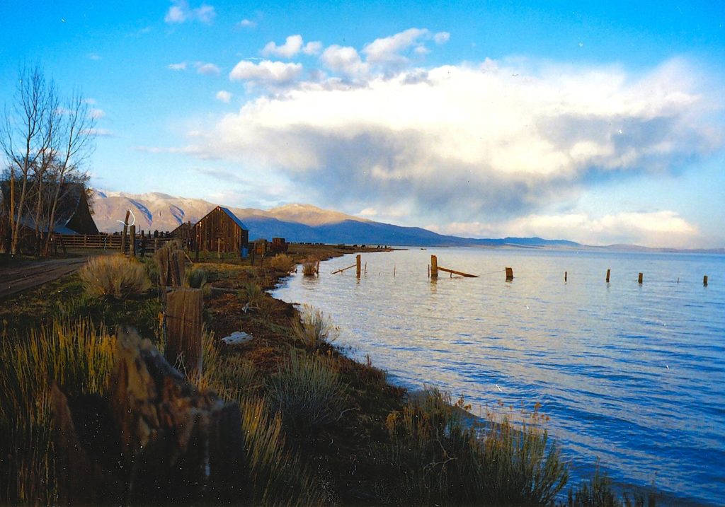
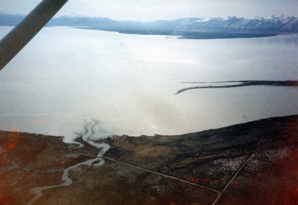
Honey Lake, February 1984. To the right is the Hartson Sand Ridge. Photograph courtesy of Bob Sorvaag
The winter of 1861-62, is one for the record books for the entire West Coast.. The epic rains throughout California lasted over forty days. Thankfully, the A.L. Tunison diaries provide a glimpse of what happened locally and elsewhere.
The previous two winters had been dry. By the end of November 1861 there was a foot of snow in the Honey Lake Valley. Then on December 8 and 9, heavy rains began. On December 18, Tunison received news of flood damage elsewhere and writes, “Good flood in Sacramento Valley. Water 15 feet deep in Sacramento City. Boats run on Main Street in Marysville. Great many cattle lost. Slide on Sierra Nevada Mountain at Washoe covered up a quartz mill, injured two men, killed another. Two bridges gone on the Truckee River.”Continue reading Weather Whiplash of the 1860s→
Diamond Mountain, circa 1940. Courtesy of Margaret A. Purdy
A point to ponder. Lassen Advocate, Susancville, California 22 October 1909: “The weather prophets say if this coating snow on the summit of Diamond Mountain lasts any considerable time without melting, we may expect a light snowfall this winter. Some of those weather prophets have been watching this indicator for thirty years or more, and ought to know.”
It has been toasty warm around these parts in July. It should be noted the summer of 1931 was of Susanville’s hottest and driest on record. A heat wave lasted nearly two months, with little respite. In July and August, only eight times did the high temperature dip below 90. In July there were nine consecutive days when the high was over 100. On July 19 and 20 was it ever hot, both days registered 106. It was also dry. On June 16th .03 inches of precipitation fell. Not another raindrop fell on the town for the next four months, until October 17th when .30 inches was recorded.
In cae you were wondering the first week of July 1876, incidentally witnessed Susanville’s hottest ever recorded temperature–108 degrees–and it was reached on three different days.
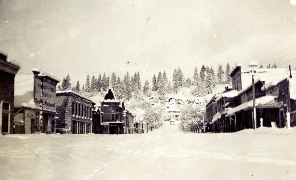
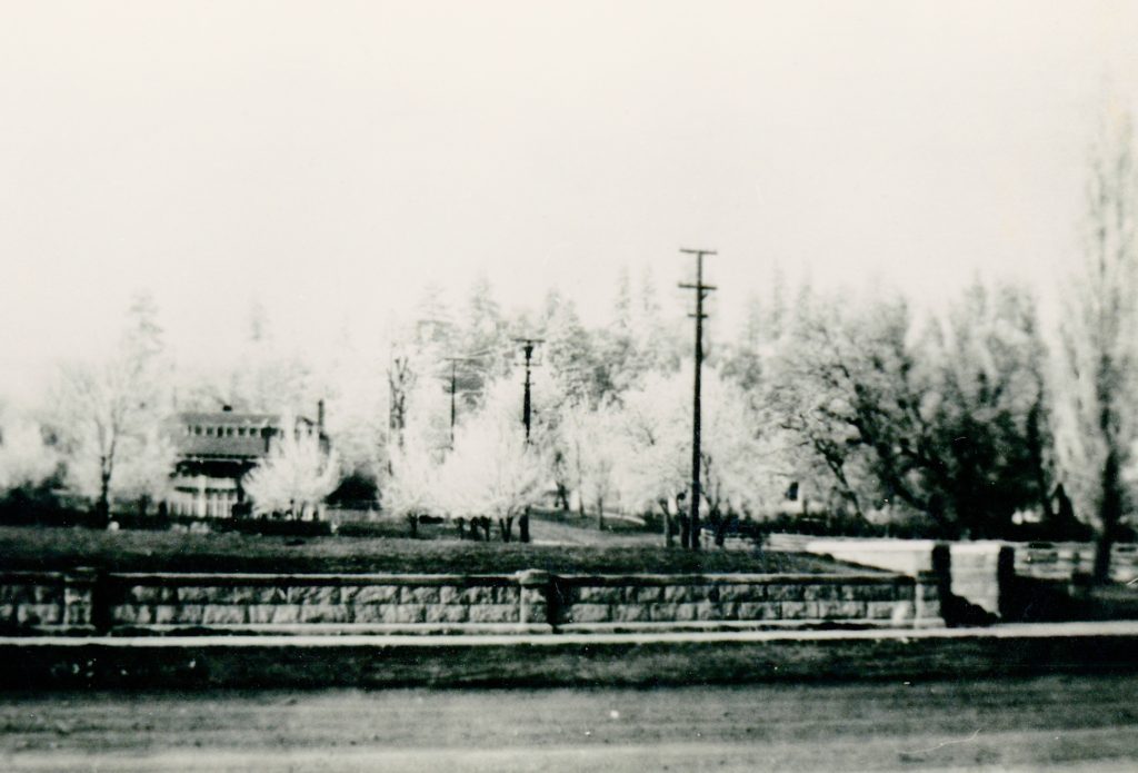
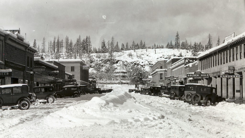
Main Street, Susanville, 1927. Note you can see where the fire burned above the Elks Lodge in 1924.
Late spring snowfalls are not unusual. Just like their counterparts of early fall snowfalls, they share a common trait—the snow melts quickly.
On March 25,1924 the Susanville area received anywhere between 18 inches to two feet of snowfall. Within twenty-four hours there was not a trace of snow. The local farmers rejoiced over their short-lived bounty, it being the driest winter on record to date. Spring rains were practically non-existent. It was a prelude of thigs to come. California would experience its worst forest fire to season to date.An interesting tidbit, the region did receive any measureable precipitation until September 15.