Tag Archives: Natural History

Lassen Park’s Seismograph Station

The Seismograph Station, 1930—National Park Service

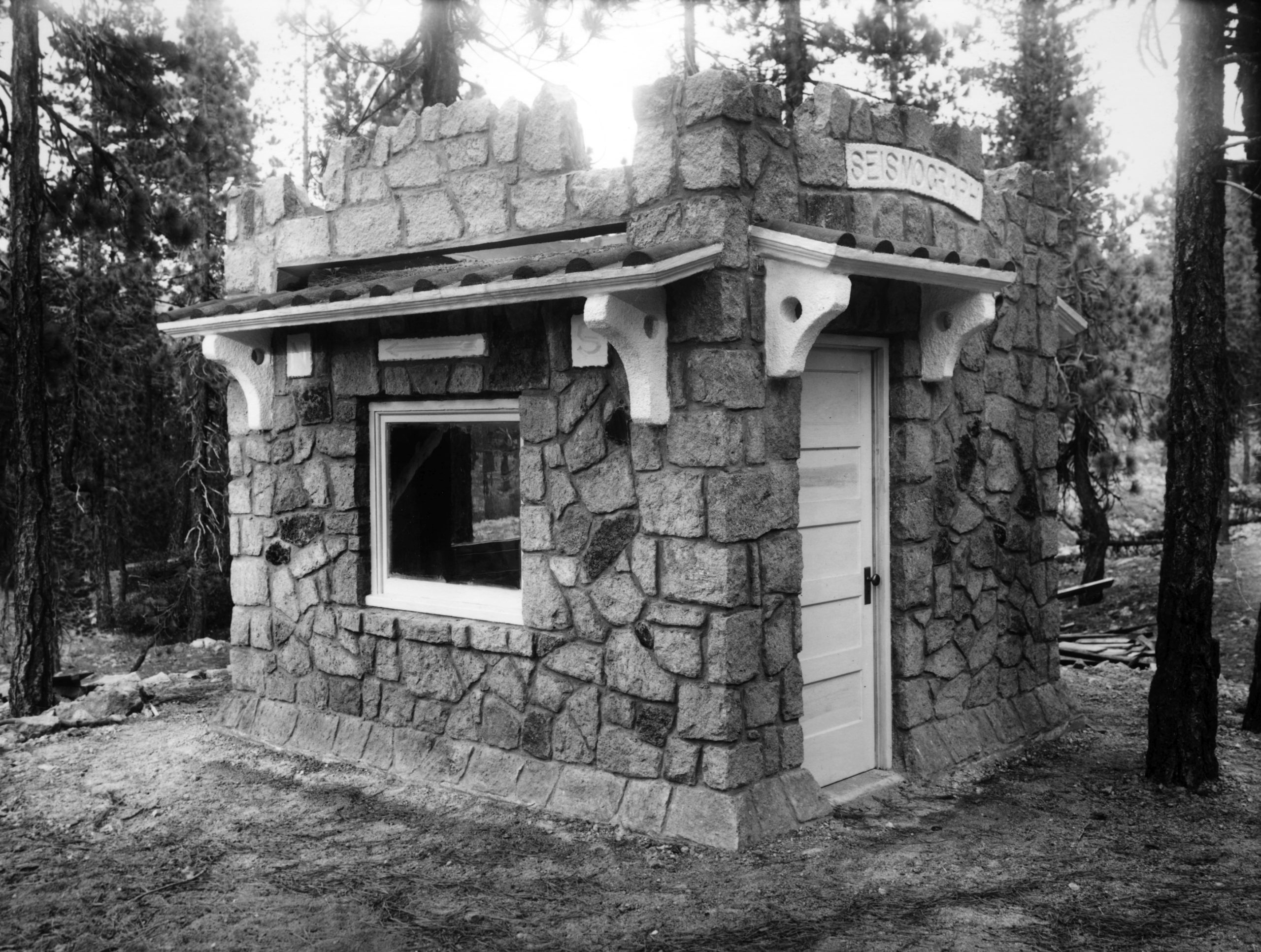
During the 1920s, the volcanic activity at Lassen Peak had greatly diminished. However, that did not mean that interest lessened. Dr. Thomas A. Jagger, a leading volcanologist of that era, had plans for Lassen. In June 1925, he visited Lassen Park to address a congressional delegation that was on a fact-finding trip. He urged that funding be appropriated so that Lassen Peak could be monitored, as had been done in Hawaii. His request was granted, and in July 1926, he announced the forthcoming establishment of the Lassen Volcanic Observatory by stating, “We intend to have the observatory in operation by September 1. By placing an observatory at Lassen the government indicates the importance of carefully recording all data concerning active volcanoes.” In September the observatory became a reality under the auspices of the United States Geological Survey (USGS) which put R.H. Finch in charge. Seismographic instruments were installed at Manzanita Lake and Mineral. A third machine was placed in the fire lookout on Mount Harkness when the lookout was built in 1930.  The USGS closed the observatory operations in 1935.

On a final note Jaggar stated that Lassen Peak’s next eruption would occur on its southwestern flank.

Subscribe

Early Day Fire Trails

Among the pines, circa 1925

In the fall of 1928, Lassen National Forest Supervisor W.G. Durbin came up with an ingenious plan for fire trails. He spent considerable examining old livestock trails and abandoned early day roads which could be put to another use as fire trails. Work began making improvements to these old routes that Durbin thought would be ideal in transporting fire fighters and equipment. There was the added benefit once the trails were cleared they would also act as fire breaks.

Subscribe


Where Are We—Caribou Lake

Caribou Lake, July 11, 2022

Caribou Lake, and nearby Silver Lake is the upper watershed of the Susan River. The lake is also a jumping off point for the Caribou Wilderness Area. When gold was discovered in British Columbia in 1858, a number of miners, including some Honey Lakers, rushed there.  It was known as the Cariboo. It should be noted that early records spelled lake’s name the same. One of the mining enterprises there was named the Neversweat.

On August 11, 1883, J.H. Slater filed for the water rights to both Caribou and Silver Lakes, along with the right to install dams and gates. In September 1883, Slater hired 12 men working at Caribou Lake to install the first headgate. It should be noted Slater owned what is today the Fleming Unit, of Honey Lake Wildlife Refuge, and was a civil engineer.

As to the Stella Stiles divorce she was married to Harry Cain. While many may not be familiar with the Stiles name, there are several Stiles descendants who subscribe to this site. Where Monsignor Moran Hall is located in Susanville was purchased from the Stiles family. Willard Hill and the Willards are part of the Stiles clan. One of my favorite Stiles descendants was Philip Hall.

Anyhow back to Harry Cain, Stella’s ex. In the summer 1905, Harry Cain, along with James Wallin and Hi Skadan  went on their annual summer excursion to camp and fish at Silver Lake. A couple days out,  things went wrong. On the morning of July 7, Cain went over to fish Caribou Lake. He had a small folding canvass boat. Wallin and Skadan remained at Silver. That evening Wallin began to prepare dinner, but Cain was not there. The two men went over to Caribou, and found Cain’s boat adrift, but no sight of him. Since it was nearly dark, Wallin and Skadan returned to camp. The next morning, they were back to Caribou, where they found Cain’s body at the bottom of the lake, about twenty feet from shore. The body was retrieved taken to Susanville for an Coroner’s Inquest, and later interred in the Susanville Cemetery.

Donate

Before Hetch Hetchy

Prattville Hotel, 1899. Mary Dale Folsom

Long before Hetch Hetchy and Lake Almanor, too, there was an episode to use the abundant water resources of northern Plumas County to supply San Francisco with its water. That resource specifically was the numerous springs of Big Meadows, now a part of. Lake Almanor.

The Plumas National newspaper of Quincy on March 1, 1882 contained an article “Lively Times for Prattville.”  An excerpt states “For some time past San Francisco capitalist have been making investigations on Feather River with a view, it is said of taking water from that stream to the city. The sources of the river being enormous springs in and near Big Meadows, it is always clear and pure. The character of the country is such that there is no fear of the water ever being injured by mining above Bidwell’s Bridge (located near present day Canyon Dam). These considerations have led to the scheme of starting a ditch in the canyon below the bridge, the ditch is to be thirty feet wide and six feet deep. This would be continued to some suitable point where piping would be begun for carrying the water to the city. Dam and reservoirs would be unnecessary, the volume of water in the river nearly the same at all seasons. This would be an immense undertaking, but it is said that money enough can be had to carry it through. How the projectors will get the water across the bay to San Francisco has not yet been heard.”

Subscribe

Susan River Fish Kill

Richmond Road Bridge, circa 1910. Courtesy of Lola L. Tanner

One of the stranger side effects of the national prohibition had to do with a one time fish kill in the Susan River. There was the issue what do with the confiscated alcohol usually referred to as jackass brandy or “dago red” wine. In the summer of 1923, Lassen County Sheriff Carter seized 500 gallons of red wine at Westwood. He did not have ample room to store the evidence. He asked the District Attorney’s. Office for approval to dispose of it, which was granted. Carter instructed his deputy sheriff A.C. Hunsinger to bring a truck to the jail to dispose of the wine and it was poured into the Susan River. However, the wine killed some of the fish in the river. Game Warden W.J. “Spade” Lee was not pleased. He asked the Sheriff to find an alternative way to dispose of confiscated wine in the future.

Donate

Lassen County’s Only National Monument

Cinder Cone, 1967–National Park Service

On June 8, 1906, President Theodore Roosevelt signed into law the Antiquities Act. In its initial conceptual form was to protect to prevent looting of archaeological sites. It was later revised to include historical sites and also landmarks of scientific importance. Once a site designated it became a National Monument.

Louis Barrett of the Lassen National Forest was concerned about two sites within its jurisdiction that could be developed into commercial tourist attractions—Cinder Cone and Lassen Peak. In the spring of 1906, in an effort to ward off future claimants he started a petition to make Cinder Cone and Lassen Peak into a national park. This did not gain the traction Barrett desired.

For Barrett, the passage  of the Antiquities Act came at an opportune moment. It provided him with another way to protect the features of Cinder Cone and Lassen Peak. He surmised the opposition to make them National Monuments would be minimal, for less than 10,000 acres of public land would be withdrawn, versus 100,000 acres for a Lassen Peak National Park.  At the same time, the national monument designation would not interfere with the establishment of a national park at a later date.

In early 1907, Barrett submitted the necessary paperwork for the creation of two national monuments—Cinder Cone and Lassen Peak. U.S. Secretary of Interior James Garfield liked the concept of two smaller national monuments better than a proposed national park. Of course, the maintenance of national monuments would be nominal compared to a national park. With no opposition, proclamations were prepared and submitted to President Roosevelt.  On May 6, 1907, Roosevelt established the Cinder Cone National Monument (5,120 acres) and Lassen Peak National Monument (1,280 acres). They became the six and seventh national monuments established under the Antiquities Act.

The movement, however, to create a Lassen Peak National Park did not fade away. One of the biggest obstacles was it was not well known, even in a regional sense. That all changed on May 30, 1914, when Lassen Peak erupted, and with it nation wide publicity.  On August 9, 1916, Lassen County lost its only national monument, when it was incorporated into the newly created Lassen Volcanic National Park.

Donate

An Unusual Fish Kill at Lake Almanor

Camp 38
Camp 38, Red River Lumber Company at Lake Almanor circa 1925—Hank Martinez

One of California Department Fish & Game’s concerns with the creation of Lake Almanor was the lack of a fish ladder at the dam. While the issue was being debated in the summer of 1916 occurred a massive fish kill at Lake Almanor. Deputy Fish & Game Warden Frank Cady went to the lake to collect some samples to be analyzed. The fish, it was discovered, did not possess any disease. The problem was with the. lake itself and water quality. There was a tremendous amount of vegetative matter decomposing in the lake from logs, brush and such from the initial flooding. It had all the characteristics of millpond, and coupled with warm summer temperatures was the problem of the fish kill. Once fall arrived with cooler temperatures, along with the rains, the water quality improved, and so did the health of the fish.

Donate

Where Are We—Susan River

July 11, 2022

This view of the Susan River was taken near the headwaters at Silver Lake.  In 1934, in the case best known as Fleming vs. Bennett, would more or less once and for all settled not only the water right issues to the Susan River, but all of its tributaries. The State Department of Water Resources, per court order, intervened and put together a complete adjudication, which is still used today.

Tim

Lassen Park’s Bumpass Hell

Bumpass Hell
Bumpass Hell, 1908, Courtesy of the Sifford Collection

On September 10, 1864, Pierson Reading and Kendall Vanderhook Bumpass filed a claim there for “all the minerals there for mining purposes.” Their claim became known as Bumpass Hell, a year prior to another event that some have attributed to the origin name.

In September 1865, Bumpass acted as a tour guide for Watson Chalmers, publisher of the Red Bluff Independent. Upon arriving at Bumpass’ mining claim, Chalmers wrote, “On turning the ridge all the wonders of hell were suddenly before us and the descent into hell was easy.” Bumpass warned Chalmers to be cautious while walking around the boiling mud pots, for the ground was not as stable as it appeared. Alas, that was exactly what happened to Bumpass on this visit, as one leg broke through the crust into the boiling mud. For relief, there was a nearby snowbank wherein Bumpass, using a handkerchief, wrapped his leg with the snow.

Over the years, others would fail to heed the warnings at Bumpass Hell, as well as Devils Kitchen, and receive severe burns from falling through the soft ground adjacent to the mud pots. The worst of these instances occurred in August 1930. Harley Pinson, age sixteen, was visiting the park with his parents. They were at Bumpass Hell where the tragic event occurred. Harley walked over to a mound to have his picture taken. At that point, the ground gave way and nearly “swallowed” him, for he was submerged nearly to his neck in the boiling mud. Heroic efforts were made to rescue him, and he was taken to Red Bluff for medical treatment. The burns were so severe that Pinson died four days later.

Subscribe

How Deep Is Honey Lake?

Honey Lake Regatta, 1987

One of the perennial questions concerning Honey Lake, when it has water,  is its depth. It is a relatively shallow lake, known to go dry for extended periods. There are a number of variables about the depth, due to the fluctuation of the level of the lake. The east side of the lake is the shallowest. Carl Caudle a civil engineer who resided near the lake’s eastern shore from 1909 to 1942 monitored the lake level there. On an average he recorded a depth of two feet. However, in the spring of 1914 and 1938, both years of record breaking precipitation, the east shore had a depth of six feet. The west side of the lake has the deepest points up to twenty-five feet during years of heavy precipitation.

Honey Lake, 1997.

In late December, 1940  Asa Brown and Jack Sawyer, state fish and game employees conducted a sounding of the lake. They started at the northwest corner, using a measuring pole took measurements every 300 to 400 yards. They recorded a maximum depth of 10.8 feet, and the shallowest at two feet. The lake on the average varied between four and ten feet. In the spring of 1987, Mark Totten and several others participated in an informal sailboat regatta on the lake. Using a depth finder, the areas traversed on the lake averaged seven feet.

Never miss a story, click here.